Three Rivers
Hudson~Mohawk~Schoharie
History From America's Most Famous Valleys
The
Mohawk Valley
Its
Legends and its History
by
Max Reid
New York and London G. P. Putman's Sons
The Knickerbocker Press, 1901
with illustrations from photographs by J. Arthur Maney
Chapter XVII Canagera, One of the Mohawks' Castles
I have before me a letter from the director of the Bureau of American Ethnology, at Washington, in which he suggests that a paper on some recent discovery of an Indian castle site near the city of Amsterdam be prepared and sent to the American Anthropologist for publication, and then he says: "You will see by the enclosed list of publications that this bureau has published very little in regard to the tribes of your State." It does seem strange that there has not been more written about the Mohawk Indians. Located as they were when Champlain invaded the Mohawks' country, in 1609, between Oneida Lake and Fort Orange, they, with the assistance of other tribes of the Iroquois, stood as a bulwark between the savage Indians and Frenchman of Canada, and the struggling settlements to the east and south, up to the period of the ending of the French war, in 1763.
Undoubtedly the assistance the Mohawks gave the earlier settlers of the Mohawk Valley, and their inveterate hatred of the Algonquins in retaliation for the defeat they suffered by Chaplain's help in 1609, saved the Mohawk River from being the southern boundary line of Canada. Nearly all the history of the valley dates from the time VanCurler and his little band of hardy pioneers settled at Schenectady in 1662.
One of the most noteworthy of those sturdy Dutchmen, next to Van curler (or VanCorlear), was Jan Barentse Wemp, who arrived in this country and locate in Beverwyck, in 1643 or 1645. The record says that he married twice and had six children. The suffix, se to the name Barent, indicates that he was the son of a Barent Wemp (Wemple). Three of his children were son, whose names were Myndert, the eldest, and Barent, who was born in 1656, and married Folkje, daughter of Symon Volkertse Veeder, and had ten children. He was appointed captain of a company of foot by Lieutenant-Governor Leisler, in 1690. He had a son, Jan barentse Wemp. The name of the third son I have not been able to ascertain.
Jan Barentse Wemp, the elder, was one of the original fourteen pioneers who settled in Schenectady in 1662. It is said that Governor Stuyvesant granted the first patent of land (an island at Schenectady) in 1662, to Jan Barentse Wemp and Jacques Cornelise Van Slyck, a half-breed. This island was sometimes called Wemp's Island, and is not known as Van Slyck's Island. Jan's name is connected very closely with the early history of Schenectady, and his descendants may be found among many of the prominent families of the whole Mohawk Valley.
Myndert, the eldest son of Jan Barentse Wemp, had a son, Johannes, also called Jan, or Johns, who, in 1711, lived in the "Mohawk's country, on the Mohawk River." On the 11th day of October of that year, Governor Hunter made a contract with John Wemp, Garret Symonce, Barent Vroman, Hendrick Vroman, and Arent Van Patten, of Schenectady, to build the fortification called Fort Hunter, at the mouth of the Schoharie River, and Queen Anne's Chapel, which was situated inside the palisade or fort. This fort and chapel were completed in 1712.
Jan Wemp, as he was called by his Dutch neighbors, owned part of the fourth flat of the Schenectady patent, which was located at Pattersonville. On December 16, 1737, he obtained a patent of 450 acres of land in the town of Florida, located east of Queen Anne's Chapel glebe, and adjoining the same on the west, and the Babbington patent of 1717, on the east. He died October 14, 1749. He married, first, Catalina, daughter of Reyer Schermerhorn, June 15, 1700, and second, Ariaantje, daughter of Isaac Swits, October 6, 1709, and had twelve children; six sons and six daughters. A few extracts from his will may be found interesting. He divided his estate as follows: To my sons Isaac and Ephraim, the westerly part of the flats on the south side of the Mohawk River, where I now live, in the Mohawk's country; to John, Jr., the easterly part of my flats; to my daughter, Maria Butler, wife of Lieutenant Walter Butler, Jr., two morgens of land, etc., and to my daughter Rebecca, wife of Pieter Conyn, two morgens of land, etc.
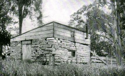 |
The Old Stone Kitchen at Wemp's |
The Water Butler was an uncle of Walter N. Butler of Cherry Valley massacre notoriety, and was killed at the battle of Lake George, September 8, 1755.
Who has not experienced a desire for a stroll in the country during the bright and beautiful October weather so common during the bright and beautiful October weather so common in this latitude? It seems to come with added force on some bright Sunday morning, and one longs to breathe the fresh air of the fields and the odors of the forest, and perhaps "look through nature up to nature's God."
One Sunday morning I yielded to such a desire, and with a comrade boarded the trolley for Fort Johnson, and being rowed across the river by a "lone fisherman," we were soon on our tramp into the Mohawk's country. Our road lay along the canal, with its steam propellers belching forth dense black smoke and pushing and pulling tow, four, or five heavily laden canal boats; on our left was the West Shore Railroad, with its long trains of rattling, rumbling cars, and screeching, hissing locomotives, while to the right, across the Mohawk, could be seen and heard endless trains of freight and passengers, passing east and west.
The road we were traveling was probably the Indian trail followed by Jan Wemp (Wemple) and his companions, en route for the Tiononderoga, to construct Queen Anne's Chapel and Fort Hunter. Leaving the massive masonry of the "two locks," which are long enough to admit two canal boats at one time, we pass the pleasant home of the MacGregors, and in due time arrive at the home of Mrs. Cornelius Wemple and Emory and Gilbert Wemple, sons of Cornelius and grandsons of Ephraim, spoken of above as having inherited the westerly half of the flats of Jan or John Wemp, which name is now changed to Wemple. We can imagine Jan and his companions, resting at the Indian spring by the wayside and drinking of its cooling water, and perhaps at that early date casting his eye over the flats with a desire for possession. The Wemple homestead of the present day is a commodious edifice of modern construction, situated near the highway a little to the west of the Indian cold spring. About one hundred feet from the house formerly stood the old Wemp place, as it was called, the home of Jan Wemp, the great-grandfather of the present owners of the farm. When the Erie Canal was constructed, in 1820, it passed through the front yard of the old house, even taking away the front steps, leaving the house so near the canal that you could step from the front door into the water. As I remember the old house, it was quite a pretentious two story edifice, flanked with two stone houses one story high and about twelve feet square, one of which was used as a kitchen, as was the custom with well-to-do families in the early part of the eighteenth century. The walls of the old kitchen are yet standing, but the roof has, of course, fallen with decay and been replaced with a temporary superstructure that looks sadly out of place on its time worn stone walls.
Our mission to the Wemple place was to find, if possible, the site of an old Indian castle called by Van Curler, in the diary of his journey to the Mohawks' country, Canagera, situated about one Dutch mile east of a large stream (Schoharie River). At this place,which is about two English miles from Schoharie River, we found abundant evidence of Indian occupation. The cold spring by the roadside and another on the hill were walled up years before the advent of Jan Wemp by previous occupants of the land,--the Mohawks. Back of the house is an old Indian ford, the only one for miles east or west over the Mohawk River. Mr. Gilbert Wemple pointed out an old Indian trail through the primitive forest, leading to Auriesville, and probably to the vicinity of Minaville.
Being asked if he had ever seen any embankment or evidence of the remains of an Indian fortification, he pointed to a path which he said led to a singular embankment, or ridge, which tradition said had been there before the advent of his ancestors. Following the path indicated, through the woods, I cam to a field that had formerly been a forest of immense trees, but which had been almost entirely destroyed by a tornado that swept through the valley a few years ago. This field has been cleared, except of numerous huge upturned trunks, and is now almost completely covered with berry bushes. To the south of this field stands the primitive forest, on whose northern edge, on a bit of high ground, is a clearing. Extending across the north side of the clearing is a grass covered embankment, about one hundred feet long, four feet wide at its base, and perhaps two or three feet high. At the east end of this embankment, and near the angle formed by a similar ridge leading to the south, is an opening about four feet wide or about the width of a gate or entrance. The easterly ridge is of the same size and structure, and extends about one hundred and fifty feet, to another angle, where it meets a well defined but irregular ridge around the edge of a swamp, to the place of beginning. On the west side of the clearing we found a rudely walled-up spring or well, filled with the rubbish of the forest. At various places on the top of the eastern and southern ridge, or embankment, large trees are growing, two of which are immense pines, estimated to be over 150 years old, showing the great antiquity of this singular work of the Indians. The size of the enclosure is about 100 feet by 150, and there is plainly visible an embankment of about 350 feet in length.
To the west of this clearing is a swamp, which could be drained to a nearby ravine by a cut about twenty feet long and two feet deep. On the north and east is a well-defined broad ditch, outside the embankment, leading to the swamp on the south. It is surely a very curious structure, and is of great interest, as there is evidence of Indian occupation on the hill and on the flats below.
After a thorough examination of the clearing and adjoining grounds, we returned to the Wemple residence, and there met Mr. Emory Wemple and our friend Harrison Chase, of Amsterdam, whose present wife is a sister of the owners of the Wemple farm, and were cordially received, told many an interesting tale, and shown many objects of interest. A curious stone slab, on a slight elevation, at a turn in the road near the large barn, was pointed out. A wide, deep indentation, evidently worn by the action of waters, ran across the width of the slab, and in the center was a smooth circular depression having the appearance of a primitive mortar, such as was used by the early Indians in grinding their corn with a stone pestle. A spot near the house was said to have been a burial place of the Indians, and a well-authenticated account of the finding of the bones of an aborigine who had been buried in a erect position was given.
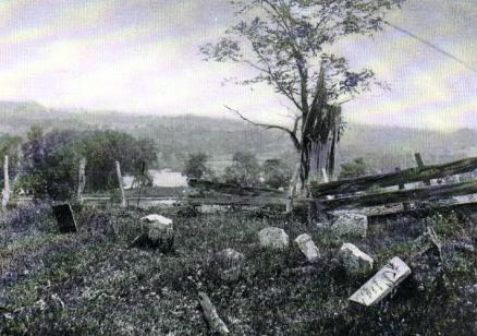 |
The Ancient Burial Ground at Wemp's |
The following day we again visited the clearing on the hill, in company with Messrs. T. B. Van Derveer and Dewitt A. Devendorf, and were confirmed in our opinion that the clearing contains the remains of an Indian fortification; but whether prehistoric or not, it is hard to tell. One of the party who was eager to explore an excavation in the clearing, descended into it and pulled down a pile of stone in his investigation. His hurried exit soon after was explained by the fact that he had put his hand upon a large snake. With a stick we removed a flat stone and exposed his snakeship, coiled for a strike. If it had been anything but a snake, we might have thought it a thing of beauty; but it would take a wonderful expansion of imagination to find beauty in a reptile. The coils of its party colored body were gracefully placed, and its flat head and about a foot of slimy length, was drawn back in graceful curves, with its small bead like eyes watching for its enemy. However, no thought of compassion or admiration could prevent poising a stone for its destruction, nor was it an impulse of cruelty that dashed the stone to its lair. But we did not crush his snakeship, as we had hoped to; he swiftly glided, with an indescribable undulatory motion, without apparent effort, to a place of safety in the opposite bank. We were sorry we did not "bruise its head," as it was the proper thing to do, according to the Scriptures.
This little incident of the snake seemed to add gloom to the solitude of the forest, and we picked our way through a treacherous swamp and were glad to get on firmer ground again. Crossing a deep ravine, which afforded an outlet to the waters of the swamp above, we turned aside from our path to see the ancient burial ground of the Wemple family, and were surprised at its populous appearance. It could hardly be called a graveyard, as it was situated in a vast field that gently slopes towards the setting sun. We counted over a hundred mounds in this ancient Godsacre, under the shade of a single giant oak. The single marble slab in commemoration of the death of Ephraim Wemple, in 1838, seemed out of place among the rude slabs of limestone, without date or inscription, that marked the last resting-place of the hardy pioneers, the descendants of Jan Barentse Wemple. Each mound was well defined and free from weeds or briers. Small slabs of gray limestone indicated the head and foot of each grave, making it apparent that a large number of children of various ages had been buried there. Mounds of greater length also marked the last resting-place of numerous adults.
About one hundred and sixty years ago, perhaps, the ground was opened to receive the remains of the first occupant of this primitive graveyard in the forest. Imagination pictures the scene. Up this gentle slope and under the shadow of towering pines, oaks, and maples, winds the funeral procession from the homestead on the bank of the Mohawk, the rude, unvarnished coffin borne by kindly neighbors, who have followed the trail from a distance to show, by their presence, their sympathy for the bereaved family. We can imagine an absence of bright colors in the funeral train, but no sable robes. Perhaps the Rev. Henry Barclay, their nearest neighbors, from Queen Anne's Chapel, stands at the head of the open grave, while at a respectful distance, a group of half naked Indians gaze stoically at the strange scene. How unmeaning to the savages, but how full of hope to the sorrowing friends, are the words of the minister as the clods fall on the coffin: "I heard a voice from heaven saying, write, from henceforth blessed are the dead, who die in the Lord. Even so saith the spirit, for they rest from their labors."
A few days later we again visited the clearing spoken of above, in company with the late A. G. Richmond of Canajoharie and W. J. Kline, T. B. Van Derveer, and Professor Maney of Amsterdam, and were again puzzled over this strange embankment. A superficial investigation of the earth in the clearing did not reveal the hoped for evidence of prehistoric relics, except some gray earth that had the appearance of ashes, which under the glass revealed the presence of tiny bits of charcoal. This was found about eighteen inches below the bottom of an old rotten stump, and was evidently of great age. A more extended investigation may reveal the evidence required.
The embankment on the hill does not prove or disprove the location of the site of Canagera, for it is said by Van Curler that this castle was without palisades. It may be of later construction, or it may antedate the Iroquois nation, and belong to the mound builders, as it bears resemblance to their curious earthworks, found in Ohio and other Western States.
I would like to add that the older residents of Fort Hunter speak of the clearing on the hill as "Yaunney's Garden," from the fact that a man by the name of Yaunney cultivated this spot about forty or fifty years ago. This may account for the absence of the hoped for Indian relics, as the cultivation of the soil would naturally obliterate evidence of Indian occupation, in the shape of ashes, charcoal, burned stone, and so forth.
In 1897, while gathering material for the history of Queen Anne's Chapel at Fort Hunter, I had occasion to visit that place to located the chapel, which was destroyed in 1820 by the building of the Erie Canal. I succeeded in doing so to my entire satisfaction, but was confronted with substantial evidence of the existence of the remains of a palisade at the greater distance from the chapel than a number of authentic documents had placed it, and looked upon it as a mystery that was hard to solve.
Reference has been made a different times and by different authors to the fact that Sir William Johnson, previous to the Revolution, had repaired the fort and mounted it with cannon. We know that it was garrisoned by a detachment of British soldiers.
A short time ago, while looking over some old letter of Sir William Johnson's I came across the following, taken from a letter written to Governor DeLancey, and dated Mount Johnson, June 6, 1755: I returned last night from the Conhogohery Indian Castle, having first been at the Mohawk Castle. At Both settlements I have first on places to build them forts. At the hither (Mohawk) castle I propose it to be nearly on a line with fort Hunter, to take in the church (chapel) as a Bastion, and to have a communication Palisades between the two Forts, which will be of small Expense, and in case of an Attack may be of great service by mutually assisting each other, and if drove to the necessity of quitting the one, they may still maintain the other.
Another letter is dated Mount Johnson, June 16, 7135: "I have last night, with much difficulty, agreed with three men to build the two Forts at the Mohawk Castle."
That the two forts were built is shown from a speech by the Indian Abraham, before Sir William in 1758. I find it in the appendix of the second volume of W. L. Stone's Life of Sir William Johnson.
Fort Johnson, Jan. 13, 1758. At a meeting of some of the Mohawk chiefs of the lower town. Present, Sir William Johnson, Bart., Lieut. Claus, Dep. Sec'y Geo. Croghan, Esq., Captain Thomas Butler; Mr. Arent Stevens, Captain Montour, interpreters; Abraham, speaker.
Brother Warra.--We come here to lay our case before you which, as it seems at present, is very precarious; listen Brother, and we will relate you our unlucky accident which happened in our town yesterday evening.
One of our young men who has been these many weeks past from home, returning yesterday, found that since his leaving home another party of men were posted in the garrison. In order, therefore, to pay a visit to the commanding officer, and bid him welcome to his garrison (not knowing that the sentries were ordered to stop any Indian from entering the fort) he came up to the gate, and to his great surprise, as quite uncustomary heretofore, was repulsed by the sentry, and after offering a second time to go in, was pushed to the ground with the butt of the gun. Upon which, seeing himself thus unfriendly used, he returned to his house, and going along one of the block houses, they emptied. . . . . upon him, and shrew him with snowballs; standing a little after, under the door of his house, he saw two soldiers coming towards the Indian town, and considering his ill-treatment a little before, went to the gate of the Indian Fort, and attempted to stop the soldiers; giving them to understand that as they would not let them enter their fort, he was unwilling they should come among the Indians; but he was soon pushed back; and one of the soldiers took up a piece of wood, and knocked him to the ground with it, leaving four wounds in his head. Upon which a French prisoner tried to take up the wounded man but was prevented by the soldiers, and obliged to run for his life to a white man's house just by there, and they followed him and would have given him some cuts, had he not pushed the door after him and kept the door shut.
Some of our young men, seeing all this, immediately ran to meet us (as we were not yet come home from the meeting at your house) and finding us as John Wemp's, where we stopped a little, told us that there was fighting and quarreling among the soldiers and Indians; we hastened home, and driving up towards my stable, in order to take my horses out of the sleigh, and put them up, in the first place found four soldiers in stable, and upon asking them what they were doing there, and desiring them to leave the stable that I might put up my horses, they immediately struck me first, and brought him to the ground, holding him some time, to present his striking me again, when the rest got hold of me, tossed me about, and had like to choke me; tore my wampum and silver medal from my neck, which they have either kept or thrown away, as I cannot find it in the place where we struggled. During the time of this two other Indians, hearing the noise, came to see what was the matter, when the soldiers were calling for help to the fort, as I found afterwards by a number of soldiers coming with drawn cutlasses, and pursued the two young Indians, who were unarmed, and one of them ran to his house, and by a strong door, which he pushed after him, saved himself, although many cuts were made into the door to split it. The other Indian ran likewise to his house, but he had not time to shut the door when the soldiers rushed into the house, fell to cutting him and gave him three wounds in his body, two in his head, and a stab in his breast, which proved very dangerous. His sister, being in the house at the same time, cried out "murder," when one of the soldiers struck at her and cut her in two places under her arm; and having a blanket about her saved her from being killed. At last an officer, sergeant, came from the fort to prevent their doing more mischief, but the soldiers were in such a rage that he was obliged to draw his sword among them and actually cut one of them in the arm; which, Brother, we mention to you for this reason that upon inquiring into the affair, we may not be charged with having wounded him; for we assure you, we had no weapons in our hands during the whole fray, nor intended at all to quarrel.
Yesterday morning, also, which two of our women wanted to cross the river in a canoe that belongs to us, and being ready to push from shore, they were pulled out of the canoe by the hair of their heads, by two of the soldiers, and the canoe taken from them. And not long ago an old woman, wife of one of the sachems, coming along the road with a load of wood on her back, was attacked by the soldiers, who wanted to ravish her, but defending herself with her axe, she prevented their design.
This, Brother, is now the true state of our complaint. [Gives string of Wampum.]
This affair occurred just at the time Sir William was expecting a large meeting of delegates of the Confederacy, and occasioned him a great deal of annoyance. However, he espoused the cause of the Mohawks, and caused the obnoxious garrison to be replaced by soldiers that were acquainted with the Indians.
In the history of St. Ann's church and Queen Anne's Chapel, published by the writer in 1897, is a photoengraving of the site of the chapel, which was situated inside the original Fort Hunter. The photograph was taken from the bridge over the guard lock looking east. On the west side of the bridge are the gates that admit the waters of the Schoharie into the feeders, which in turn empty into the main canal about one half mile away.
The figure on the left in the photo is looking across the canal towards the site of the chapel.
From the above account there seems to be conclusive evidence of the existence of two forts at Fort Hunter at that time.
From careful measurement we feel positive that the center of the old stone building was about twenty feet from the east end of the right hand stone wall, and between the two apple trees whose tops appear in the foreground.
In 1869, during a flood, the roadway on the west bank of the creek was washed away, and a large portion of its waters found exit across the flat lands into the canal some distance from the roadway. When the water subsided it was found that much soil had been washed away, exposing two lines of palisades. One line extended along the line of the road on which the old rug mill stands, and a few feet north of the fence on its northern border. The other line was at an angle of about forty-five degrees to the first line, with a well marked opening, with stakes on each side, presumably leading to the other line of palisades, about one hundred feet south.
The theory that suggests itself is, that the angular palisade belonged to the British fort, while the straight line was the stockade of the Indian fort or village, the opening spoken of being the palisaded connection between the two forts spoken of in Sir William Johnson's letters. The stakes of both palisades were about ten inches in diameter, an inner row covering the spaces between the outer row of stakes, the fortification being what was called double stockaded.
Although thirty years have elapsed since the flood that exposed the palisade spoken of, a trench dug from the fence on the south side of the lot might again bring to light evidence of this old Indian palisade. If the owner of the lot, the Rev. J. H. Enders, would undertake this work and lay bare some portion of the old stockade, he would be able to add an interesting chapter to the early history of the Mohawk Valley.
Among the persons now living who saw the remains of old Tiononderoga (Fort Hunter) in 1869, are James Voorhees, Amsterdam; John Graff, Fort Hunter; and Dr. Henry Devendorf, Mill Point.
It is usual, when one drives out in the country for pleasure, to select a day that promises to be fair and pleasant, and for that reason we are apt to see hills and valleys under the same aspects, barring the changes of seasons. I took a drive a few days ago, however, when the sky was overcast and the rumble of distant thunder was heard in the west.
Our journey led us down the river road to the Swart's Hill Road, and, as we climbed that hill in the usual laborious manner, the raindrops were falling thick and fast from the black thunderclouds overhead. We were well protected from the shower, however, and rather enjoyed being out in the downpour, although our faithful horse soon put on the appearance that is attributed to a drowned rat.
As we reached the top of that dreadful hill the view of the valley was strange and grand. Safe and snug in our buggy as a bug in a rug, we saw the river and hills under such a new aspect that we hardly recognized our surroundings. From the height from which we gazed we looked own on the Mohawk, made gray by the dashing drops of rain, while the higher Florida hills, that had been concealed from view below by the lower range along the bank of the river, spread out before us on an inclined plane, stretching upward until they disappeared in the storm clouds that formed a gray fringe along their summit, as they scurried along dropping their moisture in gray sheets on field and forest.
Looking down the river, we could see the Towereune, and Yantapuchaberg, gray and misty in the distance, and the river, narrowed by the bend at Hoffman's Ferry, winding its way along the base of those high hills that reminded one of old Donderberg and Cro'nest at the entrance to the Highlands of the Hudson. The falling rain and the blackness of the clouds almost obliterated colors from the landscape that a moment before had been brilliant with shades of green and yellow and brown.
Our destination was Glenville, a pretty little village charmingly situated on a level plateau, surrounded by high hills, and reminds one of a huge bowl on a mountain top. The view of his elevated valley, as you approach it from West Charlton, is a surprise and is very pleasing indeed. As we turned our course towards the river at Hoffman's the thunder clouds were still muttering in the east, but the sun shone brightly overhead.
Our course lay through "Wolf Hollow", one of the wildest and most charming drives in the valley of the Mohawk.
As we entered the hollow the sun brightened the roadway somewhat, but the gloom of the forests on each side was at times almost impenetrable.
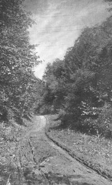 |
The Road Through Wolf Hollow. |
This hollow, or ravine, or canon, is a narrow gorge between two of the highest hills between Glenville and Hoffman's and is barely wide enough for a single roadway and the narrow creek that ripples or roars along its side in clam or in storm. The hills on each side rise to the height of three or four hundred feet, with a fringe of towering pines along their summits, and in some places just escape being termed precipitous. At one place on the western bank the earth has fallen away leaving a precipice perhaps a hundred feet high of thin ledges of slate from top to bottom. As we look up the side of the hill, the forest would be most impenetrable were it not for a thin line of gray sky that appears through the trees at the summit.
At one point a rivulet is trickling down at our feet, and as we look up, we see in the slaty bed of its almost perpendicular course a large volume of water that has been carried to it along the water courses above by the recent storm, and, as we gaze, we see it leap over the slaty ledges in myriads of tiny cascades until it dashes at our feet and goes murmuring along to the river below. About a mile from the entrance of the gorge, the ravine widens out a few feet and at the base of a cliff is seen, through the gloom, a large hole in it sides, whose impenetrable blackness makes one shiver. This is said to be the entrance to a coal mine that was opened many years ago by some visionary person who expected to make a fortune from the venture. It extended some little distance into the eastern bank, and coal was found, but in quantities that would not pay the expense of mining. The mine is said to be filled with water.
Of late years the road through the ravine has been improved and is in fair condition, in fact much better throughout than Market Street Hill. In the two mile drive through it we did not hear the howl of wolf, or see man, women, or child until near the exit two grizzled fishermen startled us by rising abruptly in the underbrush. They were collecting "scrabblers" for bait.
At the southern end of the gorge a singular rock formation has been uncovered in digging away the slate to repair the road. Above a mass of thin scales of slate is a course of gray sandstone about three feet thick in a segment of a circle inclining at an angle of forty-five degrees, and above, another thick course of slaty scales, making an interesting sight to the geologist. As we emerge from the ravine we find that we are still high above the river, a glimpse of which we catch through the trees that are scattered here and there in pleasing irregularity. In a large field to the right stands an immense chestnut tree, whose trunk is so large that two men could not span its girth. The long, narrow, pointed, drooping leaves of its very dark green foliage and the clusters of lighter green prickly burrs that hide the toothsome nuts are a very pleasing sight and give promise of a bountiful harvest. Wolf Hollow has as many moods as our hills and vales, and a traveler should see it in the brightness of noonday and also at twilight in order to appreciate its beauties and its terrors.
Copyright © 1998, -- 2003. Berry Enterprises. All rights reserved. All items on the site are copyrighted. While we welcome you to use the information provided on this web site by copying it, or downloading it; this information is copyrighted and not to be reproduced for distribution, sale, or profit.