Three Rivers
Hudson~Mohawk~Schoharie
History From America's Most Famous Valleys
The
Mohawk Valley
Its
Legends and its History
by
Max Reid
New York and London G. P. Putman's Sons
The Knickerbocker Press, 1901
with illustrations from photographs by J. Arthur Maney
Chapter
XX Canajoharie--The Hills of Florida
[Typist, 1999. Note: The date on the Indian Castle Church building is 1769,
and Mr. Reid sets the date at 1763. Please check the Contents
page for more information and articles about Indian Castle.]
The
Indian name for Canajoharie seems to have been spelled Can-a-jor-has, and
was originally applied to a singular hole in the creek that enters the Mohawk
River at that place. The Indian interpretation is said to be "the pot
that washes itself," the water seemingly said to be "the pot that
washes itself," the water seemingly boiling as it flows from this singular
hole in the bed of the creek. The name was also applied to the stream itself
and to lands south of the Mohawk in its vicinity, and in after years to the
village that grew up at its mouth after the Revolution. Historians, however,
have of late years confused readers by confounding the Indian town of Canajorha
with the Canajoharie of the present day.
All
of the south side of the Mohawk, from the Nose or spur of the Mayfield Mountains
which crosses the river near Sprakers, to the highlands at Little Falls, was
known as the land of the Can-a-jor-has, and when the Canajohaire Castle is
spoken of, it means the Indian settlement in the town of Danube in Herkimer
county, and now known as Indian Castle, which was the home of Brant and Hendrick
and the place where sir William Johnson assisted in building a church which
is called by writers, "the church at Canajoharie."
The
first name we find applied to the present village of Canajoharie is Scramling,
from a tavern kept by Henry Scramling, situated on the river "opposite
the Freys," as an early chronicler records it.
Smith
and Wells make the following entry in a journal: "13th May, 1769--At
Scramlin's we turned off from the river, pursuing a S. W. course for Cherry
Valley."--"The carriers tell us that they were paid 30 shillings
a load for carrying from Scramlin's to Otsego Lake."
The
creek itself is a thing of picturesque beauty, with its high cliffs and a
cascade where the water falls from forty to fifty feet.
Opposite
Canajoharie is Palatine Bridge, a station on the New York Central Railroad.
In a history of Montgomery County we find the following: The earliest settlement
in this town, and probably the first west of Schenectady on the north side
of the Mohawk, was a made by Heinrich Frey, a native of Zurich, Switzerland,
who, in 1688, left that city for America, bringing with him an open letter
from the mayor addressed "To whom it may concern." Upon his arrival
in New York in 1689, he received from Gov. Dongan a "location ticket"
for 100 acres of land on the Schoharie creek, but the Mohawk Valley having
more attractions for him, he soon removed thither, and settled just west of
the present village of Palatine Bridge, where he erected a log cabin on a
knoll near a fine spring. Here he laid claim to a tract of 200 acres of land,
his only title to it, aside from possession, being, probably, obtained from
the Indians. This land was subsequently included in the patent issued to Van
Slyck, from whom Frey procured a permanent title. The old homestead has always
remained in possession of the family and is now the property of S. L. Frey,
Esq., who represents the sixth generation. The log cabin was occupied until
1739, when a substantial stone dwelling was erected.
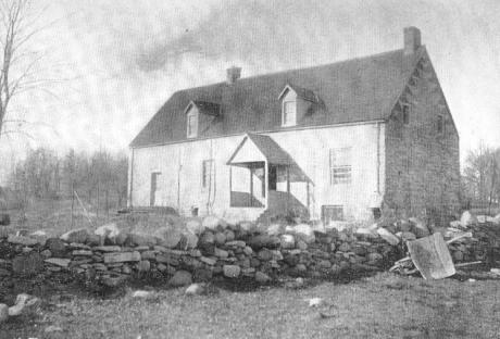 |
The
Old Frey House, Palatine, 1739. |
This
building can be seen a few rods west of the village. It has a row of port
holes on all sides, and during the French wars was stockaded and occupied
by several companies of troops. The photograph of this ancient dwelling is
represented on page 379. A picture is also given of a curious old window in
the Ehle house (1752-1900) at Nelliston, N. Y. The house may also be seen
from the car windows on the right hand side going west between the Frey house
and St. Johnsville.
For
many years travelers have viewed the valley of the Mohawk from the north side
of the river, passing under the shadow of hills that tower above them, while
their eyes have become so familiar with the southern shore that they cease
to be impressed by its beauty. The West Shore Railroad, therefore, gives to
the traveler the valley under a new aspect and opens vistas that he hardly
recognizes.
One
morning in the latter part of May, I boarded the West Shore milk train, en
route for Indian Castle. A thick haze somewhat obscured the sun, and the air
was still and warm. As the sun climbed toward the zenith, feathery shadows
were fitfully seen as we sped along the valley, while the sun itself, surrounded
by a hazy halo and thin, fleecy clouds, looked more like the full moon of
a summer night than the brilliant, blazing orb of day. The hills and valleys
were partly obscured by a light blue vapor, which revealed the gray of the
rocks but toned the bright green of forests and fields to olive tints. As
we neared the Nose, or rather Noses, just east of Sprakers, the river makes
a sharp bend from north to south, which, as we sped along, opened a charming
vista of the Mohawk, and permitted us to see a long distance up the river
between the high hills of the Noses, which a moment before seemed to obstruct
our passage.
On
both the north and south sides of the river the hills rise perpendicularly
to a great height, showing a great mass of rock with clinging vines and shrubs
and crowed with pine, cedar, and hemlock, whose dark foliage is mingled with
the lighter green of oak and ample. At some distance from the point where
we enter the pass, the northern ridge falls away into a wide ravine, or short
valley, running to the north back of the county farm.
Among
the rock of this ravine has been established an industry which, though it
is said to be a monopoly, we do not care to have transferred to our city.
I can pledge you my word that the Board of Trade will have nothing to do with
it. In that ravine lives a man who retails oil at two dollars an ounce. His
harvest begins in the warm days of spring, when the snow is disappearing,
but is of comparatively short duration. At that season he dons his rubber
boots and encases his legs in lengths of stove pipe, arms himself with a stout
club and invades the haunts of the rattlesnakes that infest that locality.
You can judge of the number slain by the fact that during the year 1899 he
sold one hundred and fifty dollars' worth of rattlesnake oil at two dollars
an ounce.
The
hill on the south side of the river is sometimes called the "Little"
Nose, but to one that gazes at its rocky elevation of 740 feet, from its base,
the name seems to be misplaced. Near its top, a little distance to the south,
is the egg-shaped opening of "Mitchell's cave," a cavern very interestingly
described by Percy N. Van Epps, in a publication called The Museum. The
entrance is made by a perpendicular drop, by means of a rope, of about 16
feet, to an opening 11 by 30 feet and 13 feet deep. From this point, by incline
plane and perpendicular descent, Van Epps, Van Horne, Hartley, and others
penetrated to the depth of 280 feet without finding any very large rooms or
extensive horizontal galleries. The cave or cavern has the appearance of having
been formed by a huge cleft in the mountain, and the exploration is made not
without danger, and with considerable discomfort.
The
name Anthony's Nose is applied to similar high hills in two other places in
New York State, one on Lake George, near "Rogers's Slide," and the
other in the highlands on the Hudson. You will probably recall Washington
Irving's story in his Knickerbocker History of New York, of the incident
which caused the last named hill to be called "Anthony's Nose."
Peter
Stuyvesant and his trumpeter, Antony Van Corlear, are sailing up the Hudson
on a voyage of discovery. Early one morning, while their sloop is passing
the highlands, Van Corlear is lounging on deck. The sun, rising over a high
hill, lights up the large red nose of Antony. Glancing from his nose,t he
ray of sunlight strikes the water and kills a sturgeon. Whereupon Governor
Stuyvesant proclaims that the hill shall be called "Anthony's Nose."
 |
Built
in 1729 by Jacobus Ehle, Nelliston |
Passing
by the rocky hills and extensive flats of the Mohawk, and many a lone fisherman,
and glimpses of the old stone houses known as the Frey and Ehle houses, on
the opposite shore, with due milk train speed we at last reached Indian Castle.
We missed the usual crowd at the station, because there are not enough people
in the hamlet to make a crowd. The object of our journey being to visit the
former home of the Indian warrior, Joseph Brant, and a church built by Sir
William Johnson in 1763, we turned our steps toward the only spire that was
visible. It being near our usual dinner house, we accosted a lady, as we crossed
the bridge that spans the Con-o-wa-da-ga, or Castle, Creek, and asked if there
was a hotel or store in the place where we could procure some food. She kindly
informed us that there were none, but volunteered the information that there
was a canal grocery about three quarters of a mile away that had a license
(?). Further inquiry elicited the information that we could procure the key
to the church of Mr. Willis Green, who lives in a large white farmhouse, with
extensive conservatories adjoining, situated near the church edifice. This
locality is interesting because it was the last home of the Canajorhees, and
the upper castle of the Mohawks during Sir William Johnson's residence in
the valley.
I
feel somewhat timid in writing about the Canajoha Castle after S. L. Frey
of Palatine has given it his consideration for so many years, and has written
so much about it. But I purpose writing from my standpoint of investigation,
trusting that if I am wrong he will correct me. As Indian Castle is situated
in Herkimer County, I also feel as though I was encroaching upon territory
belonging to historians of the adjoining county, and may differ somewhat from
their conclusions.
In
Miss Walworth's Tekakwitha is a map of ancient Indian villages, drawn
by General John S. Clark, of Auburn, who was accompanied by Mr. S. L. Frey
when sites of the villages were located. Although all other villages are represented
as having changed their location frequently between 1642 and 1700, the Canajorhees
seem (according to this map) to have been permanently located about two miles
north of Palatine Bridge, and that they were never located at the village
now known as Canajoharie.
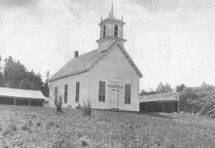 |
Brant's
Church at Indian Castle, 1763 |
We
will have to accept the conclusions of Messrs. Clark and Frey, as I know of
no better authority than they on this subject. The same uncertainty about
the Canajorhees seems apparent after 1700, until they were settled at Indian
Castle on the Con-o-wa-da-ga Creek. We know that they were there in 1755,
when Sir William Johnson built a fort for them and named it Fort Hendrick,
and that a block house was there previous to that date, but I have not been
able to ascertain the time of their removal to that locality. I have in my
possession, however a copy of an old deed which may throw a little light on
the subject. It is a deed from the Indians to Jan Wemp of Fort Hunter, and
describes the large island still in possession of his descendants. The western
end of this island is opposite Fort Hunter. It reads as follows:
".
. . . possession and demand of in and to all that great island lying and being
in the county of Albany, in the Maquas river most opposite to the Indian
castle at Canajohary, together with as much land on the main on ye southwest
side of said river as said island is in length," etc., etc. The above
deed was dated 1720. My attention was called to it by the late R. A. Grider.
The phrase "most opposite to the Indian castle at Canajohary," would
seem to indicate that it was located either to the east or to the west of
the great island at Fort Hunter.
East
of the island, on the north side of the Mohawk River, on the high hill between
Fort Johnson Creek and Dove Creek, many evidences of Indian occupation have
been found, and may have been the site of the Canajohary Castle in 1720. Sir
William bought this property in 1739, and probably between the two dates,
1720 and 1739, the Canajorhees located at Indian Castle. In another deed to
Jan Wemp, dated 1728, for lands in the same locality, occurs this sentence:
"Know that for sundry good causes and lawful considerations in moving,
but more especially for the love and affection we bear to our loving friends,
Jan Wemp and Cornelis Van Slyck," etc., etc. This would seem to indicate
a removal of the Indians to some other locality and may have been the time
that the Canajorhees moved from the north to the south side of the river,
or it may refer to the removal of an Indian village from the lands purchased
by Jan Wemp on the mainland. Evidence of an Indian village is still seen on
the hills about 1000 feet south of the Wemple residence.
Indian
Castle of today presents few evidences of former Indian occupation except
a few sunken graves in a cedar thicket at the western edge of the precipitous
hill on which stand the old church. Mr. Willis Green, whose house stands within
the line of the old stockade, pointed out a well still in use, which was said
to have been in the center of the fortifications, while back of his house
is still to be seen the outline of the foundation of the house of Joseph Brant
and King Hendrick. A hill on the opposite side of the creek is probably the
site of the old block house spoken of in the following letter from Sir William
Johnson to Governor DeLancy:
Mount
Johnson, June 6, 1755.
Sir--I
returned last night from the Conhogohery Castle, having first been at the
Mohock Castle. At both settlements I have fixt on Places to build them Forts.
At Cohogohery I propose it on the Flat Land out of Gun-Shot from the Hill
where the Old Block houses now stand, out of which upon the Point of the said
Hill I propose to erect a good Block House. On the rear of the intended Fort,
there is a clear, improved Vale run of more than half a mile, on the left
Flank it will be assisted by the said Block house on the point of the hill,
a fire between which and the Fort will clear the open land on that side; the
land is all clear and cultivated in the Front. On the right side there are
a few Bushes and small Wood to clear, when all will be open on that side for
more than half a mile. One of the Bastions to serve for a church, etc., etc.
With
the Utmost Respect
Wm.
Johnson.
Procuring
the key of the old church from its hiding place in the horseshed, I explored
the old edifice, but did not find much of interest, as the interior has been
modernized, except the windows, which still retain their small panes of glass.
The entrance, which was formerly on the west side, has been changed to the
north. I was told of an old bell in the steeple which is fractured and useless,
on account of rough usage at the time of the Indian exodus to Canada during
the Revolution. The Canajorhees attempted to take the bell with them, but
when the whites became aware of it the pursued and overtook the canoes on
the Mohawk River. It is said that in order to save the bell from capture it
was thrown into the river. It was afterward recovered by the whites and replaced
in the belfry from which it had been taken, but in a damaged condition.
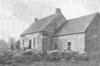
 |
The
Home of General Herkimer, Danube. Side facing river. |
Opposite
side of house, 1998.
About two
miles west of the village, still in a good state of preservation, is the old
brick residence of General Herkimer, erected in 1764.
The first
bridge across the Mohawk at Amsterdam was erected in 1821.
This bridge
was to consist of two spans, with abutments on each side of the river, and
a pier in the center. It is quite evident that the engineer who planned its
construction would never have been engaged to erect the Brooklyn Bridge, as
a portion of the Amsterdam Bridge fell of its own weight before its completion,
and the plan was changed and the bridge constructed with two piers instead
of one. The foundation of the old pier in the center can yet be seen during
the summer, when the water is clear. This bridge was carried away by a flood
in 1839, and another bridge that was immediately erected met a similar fate
in 1842. The third stood firm until 1865, when the northern span was carried
away during the spring flood of that year.
In the early
part of the spring of 1865 heavy rains had cleared the Mohawk of ice, and
continuing for a number of days filled the river until it seemed as though
the banks could hold no more. In fact, it overflowed into the Erie Canal and
filled some of the levels east of Auriesville.
At
that time a new lattice bridge was being built across the river at
Fonda, the heavy lattice timbers being in place. The banks of the
canal above having been washed away, two large canal boats passed
into the river and, floating down, struck and wrecked the uncompleted
structure.
The morning
this occurred was bright and beautiful with the sunlight of early spring,
and many people were on the Amsterdam Bridge and the banks of the river, watching
the unprecedented flood, which reached within three feet of the bridge, a
covered structure of heavy, latticed timbers, that had withstood the wear
and tear and storms of years. The water surging by was forced in huge volumes
up the piers,and fell from their sides in muddy brown cascades, and seethed
and boiled as it lashed the side of the blocks of stones, as though it were
angry that its course should be checked by such a seemingly frail impediment.
Inside of the structure on beams and lattice was the dust of thirty years'
accumulation. About ten o'clock a telegram was received that the bridge above
had been wrecked, and, with tow canal boats, was floating down the river.
The great danger to the Amsterdam Bridge was instantly recognized, and the
merchants locked their stores and hastened to the river side to watch for
the first appearance of the impending danger.
Soon, in the
distance, could be seen a black object, which as it drew nearer, was recognized
as a large canal boat with cabins at each end and covered deck between, and
about a thousand feet behind, a large section of the wrecked bridge with its
new timbers glistening in the sunlight. On came the boat, with the speed of
a race horse, sitting high in the furious current, and it was seen at once
that it could not pass under the bridge.
When it was
about five hundred feet away it was floating broadside with the current, but
as it drew nearer the bow swung around, and, amid the stillness of the breathless
multitude, struck the north span of the bridge about thirty feet from the
pier nearly head on, with a blow that made the old timbers bed like a bow.
The recoil seemed to force the boat back; the current catching the stern landed
it on the pier in its center, and was immediately forced up the pier by the
force of the current, until the whole huge boat was nearly out of the water.
There it hung, balanced across the pier, with every joint creaking, for about
twenty seconds, when the bow settled to the north, and with deliberate majesty
plunged its whole length into the stream and out of sight, came up below the
bridge, shaking the water from its deck like a huge levithan, and passed on
down the river. The shout that arose from the multitude was almost immediately
checked at the sight that met the eye as it again turned westward. There,
a short distance up the river, was the span of the bridge, floating slower,
but with resistless force, with the broken ends of the lattice sticking out
in front like the prongs of a grappling iron. On, on it came, straight for
the injured span, which it grappled to its wounded side, and amid the creaking
and groaning of timbers torn asunder was engulfed by the wrecked span. Without
any seeming diminution of speed, with its victim close locked in its embrace,
it floated down the river and was stranded on the flats below. The wreck was
hardly out of sight before the second span of the Fonda Bridge came down on
the south side of the river, with a rocking motion that carried it nearly
out of sight, and as it dipped in the water just as it reached the bridge,
it passed under without doing any damage save tearing off a few boards as
it came up again below.
With their
accustomed energy the village trustees took measure to establish communication
with their neighbors on the south side, and in due time an in due time an
iron span was constructed which did good service until 1876, when another
disaster occurred of a more serious nature.
During the
winter of 1876, from causes for which nature alone was responsible, an immense
ice-gorge was formed in the shallow riff near the Atlas mill. This began early
in the winter, and by spring had brown to such formidable proportions that
it seemed as though nothing but the heat of the sun would ever remove it.
During the month of February, however, a season of warm rains melted the snow
and filled the streams to their utmost capacity and culminated on the evening
of February 15th with more rain and a strong westerly wind.
Soon the ice
below the bridge began to heave and groan, with ever and anon a report like
a pistol shot, giving warning that the ice was breaking up under great pressure,
and it was at once feared that the bridge was in great danger. Persons hurrying
to their homes across the bridge through the darkness reported that the planks
that constituted the floor of the bridge were raised in front and behind them
as they swiftly sped from the impending danger.
In those days
we had no electric lights, and the gloom along the river bank was impenetrable
to persons standing near the bridge.
It was a fearful
night. The roar and swish of the Chuctanunda in the distance, the mournful
hum overhead, as the wind whistled through the wires and the iron bars of
the bridge, the dismal rain drops, the thick, misty blackness of the night,
the cracking of the ice, and the fearful gorge with its overshadowing horrors
in the distance, were enough to make a person shiver with nervous terror.
About ten
o'clock at night the belated spectators were aware of the movement of the
ice, and an once tried tin vain to pierce the impenetrable darkness that brooded
over the gorge in the distance.
Soon an unwonted
sound, like the grinding, crashing and rending of an irresistible body in
motion, was heard.
Closer came
the sound, and peering with straining eyes into the gloom, we saw for an instant,
before fleeing to a place of safety, the shadowy whiteness of a moving wall
towering above our heads, and heard the sound of falling bricks and timbers
from buildings wrecked along the bank. As we ran, we turned and saw the wall
approach the bridge, strike it, and bear it along in front of it, with no
more apparent effort than if it had been composed of cardboard, and pass on,
leaving behind the dismantled piers and the flood of water that was already
over spreading the banks of the river, and the total wreck of the substantial
stone and brick building of Charles Spalt, near the bridge. If this was a
fearful night, the morning brought a despondent day to those who had suffered
from the flood, from wrecked buildings, and the loss of the life of a child
as the parents were trying to escape from their threatened dwelling.
The frame
dwellings on the north bank of the Mohawk, in the rear of Charles Spalt's
shop, had been moved from their foundations by the gorge, and were immediately
surrounded by water. In one of these was George Laimbier, an elderly man,
confined to his bed with illness. He was removed to a place of safety with
difficulty. Mr. Needhan occupied another dwelling, and attempted to make his
way through the water with his three children clasped in his arms. One of
them slipped from his grasp into the water, and in the darkness and confusion
was drowned.
Three other
children were discovered by their cries to be clinging to a bush in the water.
It is remembered that John F. Morris, attracted by the cries of distress,
dashed into the water at the risk of his life, and one by one brought them
in safety to dry land.
FLORIDA
The
town of Florida, is in the form of a triangle, with its base, so to speak,
on the Mohawk River and its apex at the junction of Schenectady and Schoharie
Counties, a little southwest of Miller's Corners. This land was formerly part
of the grant of eighty-six thousand acres to Walter Butler and forty-two others
in 1733, and afterward the fourteen thousand acres of Sir Peter Warren's estate,
and the grants to Edward and Phillis Harrison, Anne Wilmot, Maynard and Elizabeth
Guerin, Henry Crosby and William Crosby, Jr., the last named grants extending
along the borders of Schenectady County, from Schoharie Creek to the Mohawk
River.
At
that date (1735), all of the country in this section of the colony of New
York was called Albany County, and the country west of Schenectady township
was spoken of as the Maquaase country, or the country of the Mohawks.
In
1788 the country north of the Mohawk River was known as the town of Caughnawaga,
and south of the river as the town of Mohawk.
Florida
was formed from the town or district of Mohawk, March 12, 1793, and its first
town meeting was held in April, 1794, at the house of Ezra Murray.
The
triangular section of land spoken of was named Florida. It is not recorded
who gave it that name, or why that beautiful Spanish word was selected. July
23, 1898, is the date of one of the many pleasant drives which the writer
has enjoyed on the Florida Hills. Out road led past the Serviss & DeGraff
mill in Mudge Hollow, which stands on the site of the first sawmill erected
at that place, and owned by one Andrew Frank. About the beginning of the century
there were two grist mills and a tannery located at this place. The mills
were owned by a Rowland and Mudge and McDonald, and the tannery by Bethuel
Dean, the grandfather of Luther L. and James Dean, and the other children
of John, Daniel, and Henry Dean. Bethuel Dean's name is found in the early
records of Amsterdam, then living near Cranesville. Later he bought a farm
on Yankee Hill, which passed to his son, John, and was occupied by him at
the time of his death.
A
letter from Oliver DeLancy to Sir William Johnson, October 26, 1765, says:
"I have directed Mr. John R. Bleeker to survey Sir Peter's (Warren) Patents
at 'Chuctanunda' and lay them out in lots of one hundred acres each. He seems
to apprehend some interruption from the Indians. In such case I beg you will
prevent their giving any trouble."
It
would seem from the above that the land now known as Florida, or at least
that portion of it near the mouth of the South Chuctanunda Creek, was designated
by the owners of the patent as Chuctanunda, while that to the east was called
Warrensburg, or Johnson's Settlement, and that Indian families were located
near the creek, and probably cultivated the flats on which the fifth ward
of Amsterdam is located.
Turning
to the left after passing the site of the old mills, our road led us over
the first range of hills on the south bank of the Mohawk, which gave us a
glimpse of the valley to the north and east. Coming to the old red brick house
of John Van Derveer, we are reminded that we are in the vicinity of the homes
of the earliest settlers, and a little further on we pass farms that bear
names of the pioneers of Florida, Rowlands, Hubbs, Herrick, Thayer, Luke,
Staley, Billington, Stewart, Van Slyke, Schuyler, Ferguson, McKinney, Ernest,
Schuler, McClumpha, and a host of others, and on the top of a high hill, midway
between the homes of Charles Ferguson and Fletcher Ernest, we stop our weary
horse to gaze on the scene before us, and are more at a loss than ever to
understand why this beautiful country was named Florida. It is said that the
name was given to the peninsula by the Spaniards, in allusion to the aspect
of the country, the name signifying florid or flowery. It is also said that
Ponce de Leon, who was in search of the fountain of life, touched the mainland
rich with flowers on Easter Sunday, march 12, 1512 (Easter was called by the
Spaniards, Pasqual Flores--the Feast of Flowers), and christened the country
Florida.
In
the grand view before me I can see no flowers or palm trees, no live oak and
cypress covered with moss and mistletoe, no stately magnolia or ambitious
mangrove or coconut. The orange, the myrtle, the jessamine, the cork tree
are not in sight. In place of plantations of side leaf bananas, we see the
tall stalks of corn and the flowering potato. No swamps or stagnant rivers,
with lazy alligators and gigantic turtles basking in the sun, no birds of
brilliant plumage and screaming, discordant notes, or lazy, ne'er do well
Negro boys and olive brown maids playing in the sand, No, this is not the
Florida of Ponce de Leon, Narvaez, and De Soto, but it has a beauty of its
own that is more attractive to the hardy northerner. As I gaze from the vantage
point of the high ground south of Minaville, there is in view to the west
the evergreen slope of Bean Hill, the highest point of land in Montgomery
County, with its cultivated sides bright with meadow and forest, shielded
from the western sun by its own vast height. To the east is the State road,
opened in 1812, to avoid the high hill on which we stand, and to make it easier
to transport the heavy cannon and ordnance stores to the forts on the Western
frontier.
In
front of us and all around us are fields of grain and meadows of clover and
timothy that have already bowed their heads to the reaper and mover, leaving
great patches of ivory tined stubble, and making a portion of the landscape
look like a section of a huge crazy quit. Here and there are great fields,
dotted with innumerable tiny hillocks of darker hue, each little hillock disappearing
as the well laden hay wagon passes near and adds to its load. In the distance
these towering, rounded loads remind one of huge elephants, or, perhaps, a
mastodon wandering aimlessly over the vast fields. Wheat, oats, and barley
are still nodding their heads, waiting for the reaper, but the sheaves of
rye that dot hill and plain remind us that harvest is at hand. All along the
road we pass orchards of apple trees and clusters of minor fruits, houses
and fences in good repair, and no deserted homes.
The
hill on which we rest might well be called historic ground, as we stand in
the center of a mile square, settled by one of the first pioneers of the town
of Florida.
Some
time near the year 1765, one Deboise bought of Edward and Phillis Harrison
six hundred and forty acres, which was part of two thousand acres known as
the Harrison patent of 1735.
Dr.
John Delamater says: "Lawrence Schuler sailed from Wurtumberg for New
York in 1755 in company with his father and two brothers, one whose name was
George; the younger, whose name is not remembered, died in New York. Lawrence
and his brother George removed to Catskill where Lawrence married a woman
by the name of Overbaug, who had five children by a previous husband, and
whose maiden name was Sarah Deboise of French descent,and sister of the late
Col. Benjamin Deboise, of Schoharie County, NY." It was through this
wife that he probably came into the possession of the Deboise mile square,
and by whom he had three sons: Jacob, born at Catskill in 1765; Solomon, born
at Catskill in 1768; John, born in 1769, probably in Florida.
Lawrence
Schuler was born in Germany in 1736, and died February 13, 1813, aged seventy
seven years. a brother Lawrence came to this country about the same time and
settled on the north side of the Mohawk. I have not been able to learn his
name, but, as a record on a tombstone in the family plot of the Schulers reads,
"Jacob Schuler, died 1807, aged 75 years," the supposition is that
he was an older brother, and probably the ancestor of the Schulers who settled
near Manny's Church. Lawrence had three sons, namely, John, Solomon,and Jacob.
John Schuler had five sons, namely, D. Cady, Remsen, Daniel, Cholot,and Jacob.
Solomon Schuler had four sons, William Solomon, Duane, John and Jacob. Up
to this time I have only been able to ascertain the genealogy of two of the
sons of Lawrence Schuler, senior, as follows:
|
L
A
W
R
E
N
C
E
S
C
H
U
L
E
R
|
JACOB
SOLOMON
JOHN
|
Wm.
Solomon
Duane
John
Jacob
D. Cady
Daniel
Remsen
Cholot
Jacob
|
(Wm.
Solomon)
Davis
W.
James
Darius
Theo.
Hale
William
Eliza
Lydia
Martha
(Daniel)
Freeman
Henry
V.
(Cholot)
Darwin
A.
|
(James)
William
S.
Davis
|
(William
S.)
Davis
Sanford
|
It
is said that when the sons of Lawrence came to man's estate, he divided his
mile square of land, reserving two farms for himself, giving the farm lately
occupied by Henry V. Schuler to his eldest son, John, and the farm adjoining,
on the road to Minaville, to his son Solomon one each tot he east to his sons
Lawrence and Jacob, and reserving the balance, being two parts of the whole,
for the homestead farm. The old homestead formerly stood in the field back
of the present farmhouse of Fletcher Ernest, and the homestead farm comprised
the two farms now owned by Charles Ferguson and Fletcher Ernest.
Only
one of these farms remains in the family, and that is the farm given to John,
which has descended as follows: From John to Daniel, to Henry V., to Darwin
A., the present owner, son of Cholot.
Solomon
Schuler's farm has been transferred as follows: Solomon Schuler to Rufus Herrick,
Rufus Herrick to Davis Herrick, Davis Herrick, Davis Herrick to Charles W.
McClumpha, Charles W. McClumpha to George McClumpha, his son, the present
owner.
On
a hill we stopped to rest. In front of us, and about midway between the house
of Charles Ferguson and Fletcher Ernest, and directly in front of our resting
place, is the site of the first church in Minaville, and one of the first
in the town of Florida. It stood in the center of the churchyard, which was
also the first cemetery in that section of the country. Off to the east may
be seen the square tower and white building known as the Scotch church, while
in front of us, about a mile away, but hidden from sight by a woods, is situated
the successor of the old church on the hill. From Beer's History I
take the following:
Lawrence
Schuler was a man distinguished for good sense, tempered by a spirit of piety
and benevolence, and diffusing an influence of goodness and liberality through
his family circle as well as in the neighborhood. The first Reformed Dutch
church in the town was erected on his lands, as was also the neighborhood
school house. He contributed towards the erection and support of both.
To
this church the Rev. Thomas Romeyn, of Caughnawaga, was called to minister
in 1784, and he served acceptably some years. This church continued in use
until 1808, when another was erected at the "Street," one mile west,
and only occasionally was service held in the old church thereafter, and until
the frame was sold and removed from its site. The burial ground around it
had become populous, and it now contains many ancient headstones with quaint
inscriptions.
At
the present time this cemetery seems to have gone the way of all old graveyards,and
is suffering from neglect to such an extent that a passerby would hardly know
that the simple wire fence that surrounds it encloses the ashes of the founders
of Florida. The dense mass of rose and briar bushes and weeks of thrifty growth
have produced a thicket around and over the sunken graves almost as impenetrable
as the chaparral of the flowery peninsular on the Gulf of Mexico. In fact,
I was able to decipher but a very few of the inscriptions on the tombstones.
It seems a pity that this old graveyard, probably the oldest in Florida, around
which hover so many sad and tender memories, should not receive enough attention
from the proper authorities to render these old tombstones legible. The wisdom
of setting aside a fund for the perpetual care of cemeteries is apparent when
we reflect on the condition of this old graveyard.
It
is said that at the beginning of the last century Cranesville, Amsterdam (Veddersburg),
and Minaville were about the same size, with odds in favor of Minaville. Very
early in the settlement of the last named place, some wag fastened upon it
the name of Yankee Street,which was afterward contracted to "The street,"
by which name it was known for many years. At that time Port Jackson was without
a name, except Chuctanunda,and contained but two or three houses, while below,
to the east, was Warrensburg, where considerable business was transacted.
In the latter part of the eighteenth century Yankee Street was the center
or capital of Florida, where the pioneer farmers went to get their supplies.
From Beers's History we make the following extract:
Minaville,
nearest the geographical center of the town, received its name in 1818, replacing
the not very distinctive title "the street," or its less elegant
form "Yankee street," by which is was long known. It was early and
for many years quite a center of country trade. It is prettily situated in
a wide, verdant bowl whose souther rim is the Shellstone and Bean Hill ranges,
and its northern horizon a lower line of ridges, forming a woody fringe. Through
it flows the winding Chuctanunda. The quiet air of thrift and comfort that
rests upon the place is not unattractive, and one could find here a pleasant
home if seeking seclusion, the world forgetting and by the world forgot.
Two
churches, stores, a hotel, schoolhouse, cheese factory, and several shops
are comprised in the village.
The
Reformed church, the successor of the "old church on the hill,"
was built in 1808, and the Methodist Church in 1835. No wonder the stores
were well patronized, when we read the names of the farmers who traded there,
some as early as 1785: David Cady, Nathan Stanton, Ezra Murray, Lawrence Schuler,
David Schuler, Philip and Peer (Peter?) Frederick, William and Peter Young,
George and Jacob Staley, John Van Derveer, Peter and Jacob Houck, Elisha Cady,
George, Peter, and Christian Serviss, Rooleiffe Covenhoven, Asa Waterman,
John Quackenboss, Ephriam Brockway, Lewis Phillip, Philip Doty, Cornelius
Phillip, William Phillip and Cornelius Phillip, the second and a host of others.
But
why was the place called Minaville? We are told that it was named in 1818
by George Smith, who occupies a prominent place in the social and political
annals of the town,and who was a courteous and successful merchant. He married
two daughters of Judge David Cady,and built a residence which, at the time
of its erection, was regarded as the finest in the country. He subsequently
purchased and improved Fort Johnson, and dwelt there until his death.
He
was the grandfather of George Smith Devendorf, of Amsterdam, and Dr. Charles
A. Devendorf, of Detroit, Michigan.
It
is said that he named the hamlet after General Mina, a Spaniard. Why? There
were two Spanish general of that name. Gen. Francis Mina, a Spanish guerilla,
harassed the French troops under Napoleon in Spain, and accompanied by his
nephew, Zavier, was captured by the French during the Peninsular War, and
detained in Vincennes four years. He afterward went to England and became
interested in the cause of the Mexican patriots in their struggle for independence.
After receiving some aid in England, he sailed for America in 1816. In the
United States he received sympathy and substantial aid and about tow hundred
American Volunteers. At Galveston he was reinforced by one hundred more Americans,
and in April, 1817, he landed in Mexico with five hundred men and marched
direct to the capital, cutting his way through such bodies of Spaniards as
he met.
He
was successful number of engagements, but was at length surprised at night,
captured and put to death in front of the Fortress of Remedias, October 27,
1817.
This
was the man for whom Minaville was named, not because he was a Spaniard, but
because he was a brave man and the leader of American Volunteers fighting
for the independence of an alien nation, and then, as in our recent war in
Cuba, against the tyrannical Spaniards.
In
speaking of the descendants of Lawrence Schuler, I have only been able to
follow the male line of his family. I have been told that Dr. John Delamater,
uncle of Mrs. Davis Schuler, made an attempt to make a genealogical record
of the Schuler family. He succeeded very well with the male line, but the
record of the female line, with all the marriages and intermarriages, he gave
up as a hopeless task, and he having failed, I feel that I am excusable for
not undertaking it.
Dr.
John Delamater was born and reared in the town of Florida, and became a physician
of eminence. For many years he was an able professor in his calling, at Fairfield
and at Cleveland, Ohio. He died there, a "beloved physician," for
his amiable disposition, gentle manners, and goodness of heart.
On
the highest point of the Florida hills, which the French invaders in 1693
called mountains, is a tract of land formerly part of the Peter Warren grant,which
is now known as the Van Derveer farm. After the war of Revolution, between
1790 and 1791, John Van Derveer, a native of New Jersey, but of Holland descent,
settled on this land, then in its pristine ruggedness. Imagine if you can
the view that met his eye and perhaps influenced his selection of a home for
his family in the Mohawk Valley over a century ago. Coming as he did from
the sandy flats of New Jersey, the sight must have seemed grand and beautiful.
Immediately in front of him were the primitive forests,whose tops of various
shades of green and brown rolled in undulating waves as they conformed to
the receding slopes of hills that stretched away on either side of the Mohawk
River.
Westward,
hid from view by hills and forests, lay Fort Hunter, whose palisades enclosed
the ruined chapel of Queen Anne; nearer, on the north side, stood Fort Johnson
and Guy Park, both lately vacated by their fugitive owners.
A
line of gray between the river and the green bank above marked the Juchtanunda
of the Mohawk, the rock "shelter along the shore of the Indians."
Following
the bank of the river a little farther eastward, the northern Chuctanunda
pours its foaming, turbulent tide into the river which, in the distance, washes
the base of the cliff of pictured rocks. Still gazing toward the east he sees
in the dim distance the Kinaquarione of Towereune of the Indians.
The
stream itself is an avenue of commerce,and the laden bateaux of the
boatman may be seen gliding along by means of pole and paddle. Along the north
bank are trains of heavy canvass-covered wagons making tedious haste, with
four, six, and perhaps ten horses, and, perhaps, a well filled Concord coach
and file of Continental soldiers.
If
he allows his gaze to span the valley, his eye rests on another range of hills
of equal height with his own, and perhaps even then he covets the land which
after three decades became the property of a member of his family.
John
Van Derveer and his wife Katherine Conover lived in Florida over half a century,
and, with their sons and daughters, became a family of wealth and influence.
By
marriage the family may be traced to the descendants of nearly all the oldest
and most prominent families of the present towns of Florida and Amsterdam.
One
of his ancestors, Cornelius Janse Van Derveer (Cornelius, son of John from
the ferry), emigrated in the ship Otter in 1659 from Alkmaer in North
Holland to New Amsterdam (now New York). He settled in Flatbush, Long Island,
where he was magistrate in 1678-80. There he married Teyntje (Catherine),
daughter of Yilles (Giles) de Mandeville. Her father came from Gelderland
in Holland to New Amsterdam in 1659, being one of the Huguenots who were so
numerous among the early immigrants and who by their knowledge of textile
industries formed so valuable an addition to the early settlements in this
country. Cornelius Van Derveer and Teyntje his wife had numerous children,
among them Dominicus, who had several children, one of them being Tunis, who
was the first of the family to settle in New Jersey and was the grandfather
of John, spoken of above, and his brothers Garrett and Hendrick, all of whom
located in the Mohawk Valley about 1790.
The
New Jersey family must have been exceedingly wealthy for those early days
of our country, as it is said that John Van Derveer, the subject of this sketch,
brought with him to his Florida farm eighty thousand dollars in cash.
The
land was purchased of one John Watts, a relative of the wife of Sir John Johnson.
John
Van Derveer had eight children, five sons and three daughters. Of the sons,
Garrett was born in 1799, and inherited the homestead farms now occupied by
his descendants. John, at middle age, moved to Schenectady, where he died
a few years ago. Cornelius came to the village of Amsterdam, and later in
life was killed by a premature blast in the eastern part of the village, leaving
a wife and three children, J. Watts Van Derveer, at one time clerk of the
county, Emily, who married D. P. Corey, and Helena, who married Harvey Kennedy
of New York.
Jennie,
the eldest child, married Joseph Stanton, and for her second husband, John
Sherburne.
Catherine
became the wife of Peter I. Enders.
Of
the daughters, Sarah, married a Serviss, and for her second husband, James
Greenman.
Henry
Van Derveer married a Miss Conover. He died young, and his wife and son soon
followed him.
The
possession of so large a sum of money as eighty thousand dollars made it very
easy for John Van Derveer, Sr. to acquire land in his vicinity, and in 1822
he secured of Nicholas Vedder a portion of the large tract of land known as
the Tunis I. Van Derveer estate, being located on the first range of hills
north of the Mohawk River, opposite tot he homestead farm. This land was immediately
occupied by his son, Tunis I. Van Derveer, who continued to add to the first
purchase as opportunities presented themselves.
Copyright
© 1998, -- 2003.
Berry Enterprises. All rights reserved. All
items on the site are copyrighted. While
we welcome you to use the information provided on this web site by copying
it, or downloading it; this information is copyrighted
and not to be reproduced
for distribution, sale, or profit.