Three Rivers
Hudson~Mohawk~Schoharie
History From America's Most Famous Valleys
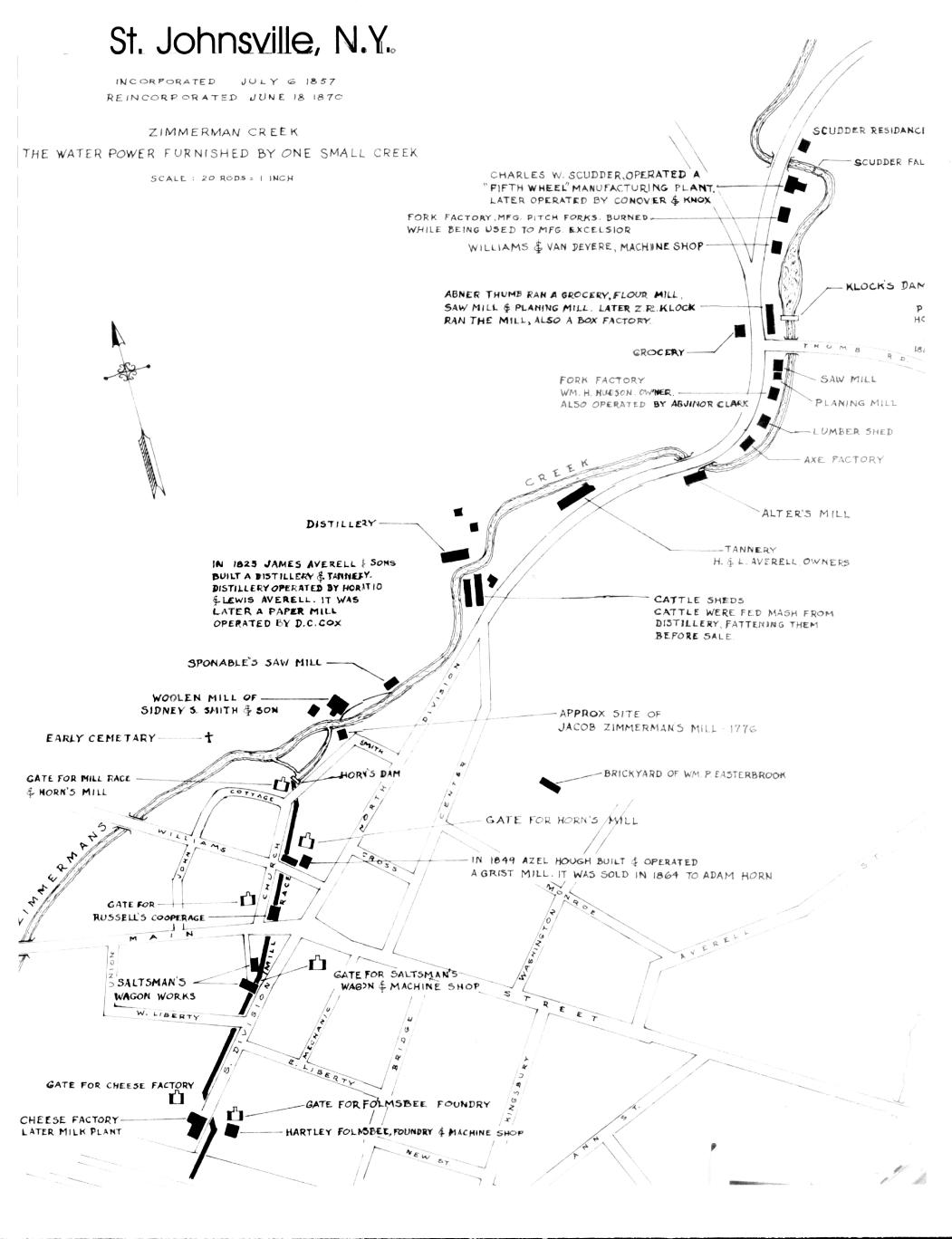
Map by John C. Dievendorf, 1982. Location of Factories along Zimmerman Creek in st. Johnsville when water power was the major source of energy is shown in this diagram-map prepared by John C. Devendorf of Amsterdam and given to the Village of St. Johnsville.
Jan. 1, 2001, sometime during the night, a dear friend of St. Johnsville, Elizabeth "Betty" Bilobrowka passed to her rest. She was an avid historian and did a lot for her community. This clipping was found in her papers and was passed on for use on the site.
The clipping is from The Evening Times, Wed., Nov. 10, 1982, Little Falls, N.Y.
MAP GIVEN VILLAGE SHOW OVER SCORE OF EARLY INDUSTRIES ALONG ZIMMERMAN CREEK IN ST. JOHNSVILLE.
At least 21 industries once were located along the banks of Zimmerman Creek between Scudder Falls, north of the village, and the stream's confluence with the Mohawk River.
A framed diagram-map showing the location of the plants, was prepared by John D. Devendorf of Amsterdam, and presented by him, a few days ago to Mayor Wilfred Y. Kraft. Mr. Devendorf noted on the back of the map that it was given in memory of John McBride, first fire chief in St. Johnsville.
In the 1800's water power was a primary source of energy, and naturally led to the construction along the creek of factories dependent upon such power. Because of the considerable drop between Scudder Falls and the river, the water could be used many times.
At Scudder Falls, site of the present village water supply dome and commercial reservoir, was located the "fifth wheel" factory operated by Charles W. Scudder, from whom the spectacular falls derived its name. The plant there, long since disappeared, later was operated by Conover & Knox, according to Mr. Devendorf's map.
Other plants, apparently clinging to the side of the gulley between Scudder Falls and Thumb Road, included a fork factory, manufacturing pitchforks; the Williams & VanDevere machine shop; Abner Thumb's grocery store, flour mill, saw mill and planning mill, which later was operated by Z. R. Klock as a mill and box factory.
Below Thumb Road were a planeing mill, a fork factory operated by William H. Hudson and also by Abjinor (cq) Clark; lumber shed, axe factor; Alter's Mill (at the point where the creek flows beneath North Division Street); a tannery (H & L Averell, owners); a distillery built in 1825 by James Averell & Sons, also a tannery, and later a paper mill operated by D. C. Cox. Nearby was a cattle shed, where the animals were fattened for market with mash from the distillery.
Then came Sponable's saw mill, a woolen mill operated by Sidney S. Smith & Sons, and Jacob Zimmerman's mill, built in 1776 near what now is Smith Street.
Just below that was Horn's Mill, which used waterpower from a raceway until recent years, and which now is Case Agway. Then there was a grist mill. Russell's cooperage (just north of Main Street), and Saltsman Wagon Works, south of Main Street and later occupied by Robert C. Failing Ford Garage until destroyed by fire several years ago.
Between that location and the river were a cheese factory and the Hartly Folmsbee Foundry and Machine Shop.
The map notes, amusingly, that there was a "pest house" located on Thumb Road in the 1880's. It is understood that during an epidemic of smallpox those who were stricken with the disease were obliged to stay at the "pest house," a sort of early day isolation facility in an effort to keep the ill persons from infecting others.
The chart given by Mr. Devendorf will be hung in the Community House.