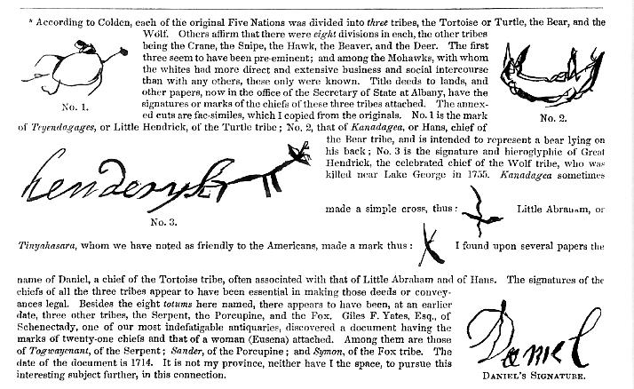
 (<--Note:
the church is known as Fort Herkimer Church. You will find a lot of information
about this church by doing a search on the site. ajb)
(<--Note:
the church is known as Fort Herkimer Church. You will find a lot of information
about this church by doing a search on the site. ajb)
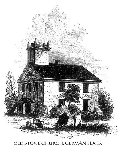
Toward the eastern extremity of the Flats, and about four miles west of
Little Falls, on the south side of the river, is one of the churches which
were erected under the auspices and by the liberal contributions of Sir
William Johnson.(1) The church is of stone, but is somewhat altered in its
external appearance. The walls are very thick, and it has square buttresses
at the corners. It was altered and repaired in 1811, at an expense of nearly
four thousand dollars. The roof (formerly steep) was raised, an upper row
of windows was formed, and a gallery was constructed within. The height
of the old windows is indicated by the arches seen over the present square
ones, and the eaves were just above the key-stones. The original tower,
with its steeple, was similar to the one at Caughnawaga. The tower, or belfry,
was open, and in it was placed a swivel for the protection of the inhabitants
against the Indians, or to sound an alarm to the people on the neighboring
hills. The pulpit, although newly constructed when the church was repaired,
is precisely the same, in style, as the original. The sounding board and
panels in front are handsomely painted in imitation of inlaid work, and
the whole has an elegant appearance. This church has never been without
a pastor since its construction in 1767, yet only two ministers have presided
over the flock during eighty years of its existence. The first was the Rev.
Abraham Rosenkrans. Before the church was built, he preached to the people
in that region in their dwellings, school-houses, and barns. He was installed
pastor of the church in 1767, and remained 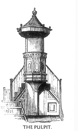 there
until his death in 1796, when his remains were deposited beneath the pulpit.
He was succeeded by the Rev. John P. Spinner, from Germany, who preached
in the German language exclusively until within twenty years, and afterward
in English and German alternately. He died in May, 1848.
there
until his death in 1796, when his remains were deposited beneath the pulpit.
He was succeeded by the Rev. John P. Spinner, from Germany, who preached
in the German language exclusively until within twenty years, and afterward
in English and German alternately. He died in May, 1848.
A few rods west of the church was the large stone mansion of the Herkimer family, which was stockaded and called Fort Herkimer. Around this, and the church, the humbler dwellings of the farmers were clustered, for so frequently did the Indian marauder (and as frequently the unprincipled Tory, in the Revolution) disturb them, that they dared not live in isolation. Fort Herkimer became a prey to public vandalism when the Erie Canal was built. The waters flow in part over the site 01 the fort, and its stones, so easily quarried, were used in the construction of a lock near by.
Two miles further westward, on a gravelly plain upon the north side of the river, is the pretty little village of Herkimer. It occupies the site of old Fort Herkimer, erected in the early part of the Seven Years' War, and known as Fort Dayton during the Revolution, occurrences at which we have already mentioned. This beautiful region, like the "sweet Vale
1 It was built upon the north side of the old German burying-ground. Near the southern wall of this church is a large brown sandstone slab, placed there by the provincial government, on which is the following inscription: "HERE REPOSES THE BODY OF JOHN RING, ESQ., OF THE KINGDOM OF IRELAND, A CAPTAIN OF HIS MAJESTY'S INDEPENDENT COMPANY OF THE PROVINCE, WHO DEPARTED THIS LIFE THE 20TH DAY OF SEPTEMBER, 1755, IN THE 30TH YEAR OF HIS AGE." Near this church, it is said, was raised the first liberty-pole in 1775. White, the sheriff of Tryon county at that time, came up with a large body of militia from Johnstown and cut it down.
255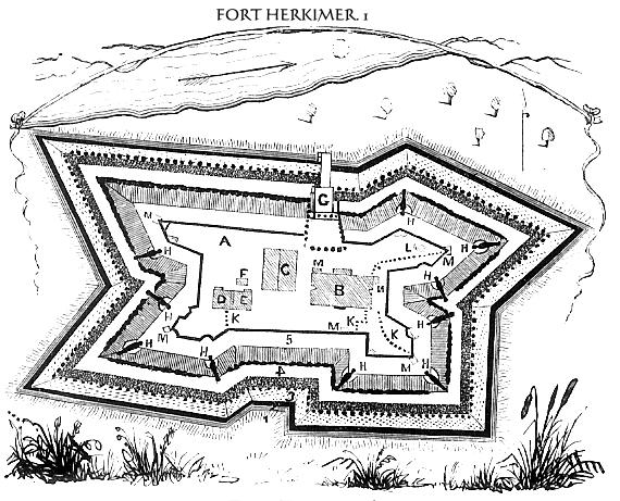
of Wyoming," was disturbed and menaced in the earlier periods of the war, and in 1778 it was made a desolation.
Owing to the distant situation of Fort Schuyler, its garrison afforded very slight protection to this portion of the valley, and Fort Dayton had become little better than a dilapidated block-house. The Tories and Indians were, consequently, bold in their marauding expeditions, and the murderer and the incendiary kept the patriots in continual alarm. All the spring and summer succeeding the flight of St. Leger from Fort Schuyler, the various settlements in Tryon county were menaced. In July, a secluded hamlet called Andrustown, situated about six miles southeast of the German Flats, and composed of seven families, was destroyed by a party of savages, under Brant. They owned a thousand fertile acres among the hills and pleasant valleys toward the Otsego Lake, and plunder seemed to be the sachem's chief object. This secured, some of the people murdered, and others made captive, the torch was applied, and the whole settlement utterly laid waste.
Success made the Indians more greedy, and toward the close of August they hung like a gathering storm upon the hills around the German Flats. Aroused (1778.) and alarmed by the tragedy at Andrustown, the people had kept scouts on the alert, and the approach of Brant from Unadilla toward the settlement was heralded by them in time for the residents to prepare for the coming invasion. These scouts came in hot haste, and informed the inhabitants that the savages would be upon them in a few hours. There was no time to look after and secure their sheep and cattle, but, gathering up the most valuable things which they could carry from their houses, the whole settlement took refuge in Forts Dayton and Herkimer, and in the old church.
Brant, with three hundred Tories and one hundred and fifty Indians, reached the borders of the settlement early in the evening.(2) It was a dark and rainy night, and he lay concealed in a ravine near Shoemakers (where Walter Butler was captured the year before) until near daylight, when his warriors were called to duty, and soon swept, like a fierce wind, over the plain. The houses were assailed, but neither scalps nor prisoners were to be found in them. At dawn the fires were kindled. Barns, filled with the product of an abundant harvest just gathered, the dwellings of the people, and every thing combustible, were set on fire, within view of the sorrowing fugitives in the fort. Having nothing but small arms, the savages did not attack the fort, but, having laid the whole plain in ashes, collected the horses, sheep,
1 I copied this sketch from a manuscript drawing in possession
of the New:York Historical Society. It was drawn by a private of Captain
Ogelvie's company, and presented by him to "Charles Clinton, Esq.,
* lieutenant colonel commanding," in July, 1758. Herkimer is there
spelled Herekheimer.
EXPLANATION OF THE SKETCH.-A, the parade; B, dwelling-house; C, barracks;
D, guard-room; E, officers' kitchen; F, the well; G, draw-bridge; H H, &c.,
ten swivel guns; K K, stockades; L, the oven; M M, &c., sentry boxes;
N, smith's shop; O, the Mohawk River; 1, terrace; 2, trench; 3, palisades;
4, parapet; 5, banqueting.
2 At the time in question there were thirty-four houses and as many barns
in the settlement on the south side of the river, and about an equal number
on the north side, at Fort Dayton, now Herkimer village.
* Charles Clinton emigrated to America from Ireland
(whither his family fled from England for refuge in the time of Cram. well)
in 1729, and in 1731 he founded a settlement in Ulster county. New York.
He was appointed lieutenant colonel by Governor Delancy, after serving with
distinction under Bradstreet. He was the father of General James Clinton
(the father of the late Dewitt Clinton) and of Governor George Clinton,
of the Revolution. He died November 19, 1773, aged 82 years.
256
 and
cattle, and drove them off over the southern hills. Four hundred militia-man
were hastily collected, and pursued them as far as Edmundston's plantation,
on the Unadilla River, where they found three scouts dead; but they effected
nothing in the way of retaliation or the recovery of property. A party of
friendly Oneidas, however, were more successful. They penetrated the Unadilla
settlement, where Brant (1) had his head quarters, burned some of the Tory
houses, took several prisoners, and brought away some of the cattle taken
from the people at the German Flats. A deputation of about one hundred Indian
warriors of the Oneidas communicated the result of this expedition to Major
cochran, then in command of the garrison at Fort Schuyler. They were a part
of those who proffered their services to General Gates, after the first
battle on Bemis's Heights, in the autumn previous.
and
cattle, and drove them off over the southern hills. Four hundred militia-man
were hastily collected, and pursued them as far as Edmundston's plantation,
on the Unadilla River, where they found three scouts dead; but they effected
nothing in the way of retaliation or the recovery of property. A party of
friendly Oneidas, however, were more successful. They penetrated the Unadilla
settlement, where Brant (1) had his head quarters, burned some of the Tory
houses, took several prisoners, and brought away some of the cattle taken
from the people at the German Flats. A deputation of about one hundred Indian
warriors of the Oneidas communicated the result of this expedition to Major
cochran, then in command of the garrison at Fort Schuyler. They were a part
of those who proffered their services to General Gates, after the first
battle on Bemis's Heights, in the autumn previous.
I returned to Little Falls toward evening and the lengthened shadows of the hills and trees heightened the picturesque beauty of the scene. The view, on approaching
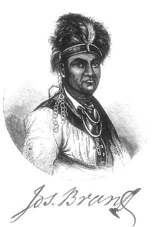
1 Joseph Brant (Thayendanegea) was a Mohawk of pure blood. His father was a chief of the Onondaga nation, and had three sons in the army with Sir William Johnson, under King Hendrick, in the battle at Lake George in 1755. Joseph, his youngest son, whose Indian name was Thayendanegea, which signifies a bundle of sticks, or, in other words, strength, was born on the banks of the Ohio in 1742, whither his parents immigrated from the Mohawk Valley. His mother returned to Canajoharie with two children, Mary, or Molly, who became the concubine of Sir William Johnson, and Thayendanegea. His father, Tehowaghwengaraghkwin, a chief of the Wolf tribe* of the Mohawks, seems to have died in the Ohio country.
(In order to keep the details of the footnote, it is used as a graphic. ajb)
257
from the west, changes from the quiet beauty of a rolling plain, enriched by the cultivator's art, and enlivened by a gently gliding river, to the rugged grandeur of lofty hills, craggy steeps, and turbulent cascades. It reminded me of two of Cole's, beautiful pictures in his "Voyage of Life," wherein is depicted the course of an ambitious youth. He is out upon a placid stream, so full of self-confidence that his guardian angel is left behind. All around is beauty and repose. The stream meanders on without a riff, but in the distance it sweeps with a majestic curve around a woodland into a mysterious region. Onward speeds the bark of the youthful voyager upon the gentle current, until the valley becomes narrower, the waters run swiftly, the tall trees and beautiful flowers upon its banks disappear, high and barren rocks wall in his view, and just before him is the wild leap of a cataract into a fearful gulf below.
The village of Little Falls is upon the rocky bank of the cascades, and
only westward can the eye see any thing from it but rocks, and trees, and
running water mingled in wild confusion. Here the high ridge of the Alleghany
range, which divides the head waters of the Mohawk and the Ontario streams
from the Susquehanna and other Atlantic rivers, crosses the Mohawk Valley,
and in ages long past, ere the 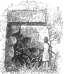 great
Falls of Niagara existed, doubtless formed the crown of a cataract almost
as magnificent, when the waters of Ontario covered the upper valley, and
a portion of its flood here found its way into the great lake that filled
the Hudson basin, whose outlet, in turn, was among the rugged hills of the
Highlands at West Point and vicinity. Such is the theory of the geologist;
and never had opinion stronger presumptive proofs of its correctness than
are found at Little Falls.(1) An obstruction here, seventy feet in height,
would cause the waters to overflow the Rome summit, and mingle with those
of Ontario by the way of Wood Creek, Oneida Lake, and the Oswego River.
The rugged shores present many incontestible evidences of abrasion by the
violent action of water, thirty to sixty feet above the present bed of the
river. Many of them are circular perpendicular cavities in the hard rocks,
which are composed chiefly of gneiss, granite, and hornblende. In some instances
masses of stratified rocks present the appearance of Cyclopean architecture,
as seen in the above cut,(2) and hundreds of small cavities, far above the
present bed of the steam, indicate the action of pebbles in eddies of water.
great
Falls of Niagara existed, doubtless formed the crown of a cataract almost
as magnificent, when the waters of Ontario covered the upper valley, and
a portion of its flood here found its way into the great lake that filled
the Hudson basin, whose outlet, in turn, was among the rugged hills of the
Highlands at West Point and vicinity. Such is the theory of the geologist;
and never had opinion stronger presumptive proofs of its correctness than
are found at Little Falls.(1) An obstruction here, seventy feet in height,
would cause the waters to overflow the Rome summit, and mingle with those
of Ontario by the way of Wood Creek, Oneida Lake, and the Oswego River.
The rugged shores present many incontestible evidences of abrasion by the
violent action of water, thirty to sixty feet above the present bed of the
river. Many of them are circular perpendicular cavities in the hard rocks,
which are composed chiefly of gneiss, granite, and hornblende. In some instances
masses of stratified rocks present the appearance of Cyclopean architecture,
as seen in the above cut,(2) and hundreds of small cavities, far above the
present bed of the steam, indicate the action of pebbles in eddies of water.
His mother, after her return, married an Indian called Carribogo
(news-carrier), whom the whites named Barnet; but, by way of contraction,
he was called Barnt, and, finally, Brant. Thayendauegea was called Joseph,
and was known as Brant's Joseph, or Joseph Brant. Sir William Johnson sent
young Brant to the school of Dr. Wheelock, of Lebanon Crank (now Columbia),
Connecticut, and, after he was well educated employed him as secretary,
and as agent in public affairs. He was employed as missionary interpreter
from 1762 to 1765, and exerted himself for the religious instruction of
his tribe. When the Revolution broke out, he attached himself to the British
cause, and in 1775 left the Mohawk Valley, went to Canada, and finally to
England, where his education, and his business and social connection with
Sir William Johnson, gave him free access to the nobility. The Earl of Warwick
caused Romney, the eminent painter, to make a portrait of him for his collection,
and from a print after that picture the engraving on the preceding page
was made. Throughout the Revolution he was engaged in warfare chiefly upon
the border settlements of New York and Pennsylvania, in connection with
the Johnsons and Butlers. He held a colonel's commission from the king,
but he is generally called Captain Brant. After the peace in 1183, Brant
again visited England, and, on returning to America, devoted himself to
the social and religious improvement of the Mohawks, who were settled upon
the Ouise or Grand River, in Upper Canada, upon lands procured for them
by Brant from Sir Frederic Haldimand, governor of the province. The territory
embraced six miles on both sides of the river, from its mouth to its source.
He translated the Gospel of St. Mark into the Mohawk language; and in many
ways his exertions for the spiritual and temporal welfare of his people
were eminently successful, and endeared him to his nation. He died at his
residence at the head of Lake Ontario, November 24th, 1807, aged 65 years.
One of his sons (John) was an officer in the British service, on the Niagara
frontier, in the war of 1812. His daughter married William J. Kerr, Esq.,
of Niagara, in 1824, and, I believe, is still living. "
1 This name was given in contradistinction to the Great Falls, now called
Cohoes, at the mouth of the Mohawk.
2 This is a view of a large circular cavity on the western shore of the
river a few yards from the rail road, and about thirty feet above its bed.
On the side of the cavity toward the river is an opening about