Page 258
The hills on either side rise to an altitude of nearly four hundred feet, and from that height the ancient cataract may have poured its flood. Immediately below the present cascades at the foot of Moss Island, or Moss Rock, the river expands into a broader basin, more than one hundred feet deep, from whose depths rocky spikes, like church spires, shoot upward, some of them to the surface of the water. Into this gulf the great cataract doubtless poured its flood, while the rocky cones, too hard to be abraded, resisted the unceasing attrition of the water for ages.
I strolled along the rail-road at twilight, by the margin of the rapids and of the gulf below; and before sunrise I went down upon the tow-path to view the scene in the shadows of early morning. Art and nature here vie with each other in claims upon our admiration. Here the former exhibits its wonderful triumphs, and the latter displays its beauty and grandeur. On the south side of the river is the Erie Canal, the passage for which was excavated through solid rock a distance of two miles. This narrow defile presented the most formidable obstruction on the whole line of that great work, and it was supposed that at least two years would be required to complete the excavation. Skill and persevering industry accomplished the most difficult portion in ninety days. The waters of the canal here
ten feet square, and over the entrance is a massive lintel, which appears as if hewn and placed there by the hands of man. Within the large cavity, which is open at the top, are smaller ones upon its concave sides. Two of these concavities are seen in the engraving. The rocks are covered with a luxuriant growth of shrubbery, springing from the rich alluvial deposits in the fissures. An exploration of them is dangerous, for some of the fissures are broad and deep. Indian legends invest these caverns with romantic interest. One of them I will repeat, in brief, as it was told to me, for it is identified with the spot represented in the picture.
Long ago, when the river was broader and the falls were more lofty, a feud arose between two young chiefs of the respective tribes of the Mohawk nation, the Wolf and the Tortoise. A maiden of the Bear tribe was the cause of the feud, as maidens often are. She was loved by both the young chiefs, and for a time she so coquetted that each thought himself beloved by her in return. Her father was a stern old warrior, and loved his child tenderly. Both chiefs had fought the Mingoes and Mohegans by his side, and the bravery of each entitled him to the hand of the maiden. Her affections were at length stirred by the more earnest importunities of the Wolf, and she promised to become his bride. This decision reached the ears of the Tortoise, and the embers of jealousy, which disturbed both while unaccepted suitors, burst into a flame of ungenerous revenge in the bosom of the disappointed lover. He determined to possess the coveted treasure before the Wolf should take her to his wigwam. With well-dissembled acquiescence in her choice, and expressions of warm friendship for herself and her affianced, he allayed all suspicions, and the maiden rambled with him in the moonlight upon the banks of the river when her affianced was away, unconscious of danger. The day approached for the maiden to go to the wigwam of her lord. The Tortoise was with her alone in a secluded nook upon the brink of the river. His light canoe was near, and he proposed a voyage to a. beautiful little island in the stream, where the fire-flies sparkled and the whippoorwill whispered its evening serenade. They lanched, but, instead of paddling for the island, the Tortoise turned his prow toward the cataract. Like an arrow they sped down the swift current, while the young chief, with vigorous arm, paddled for the western shore. Skillful as with the bow and hatchet, he steered his canoe to the mouth of the cavern here pictured, then upon the water's brink, seized the affrighted maiden, and leaped ashore, at the same moment securing his canoe by a strong green withe. The cave was dry, a soft bed of the skins of beasts was spread, and abundance of provision was there stored. At the top of the cave, far above the maiden's reach, an opening revealed a passage through the fissures to the rocks above. It was known only to the Tortoise; and there he kept the maiden many months, until her affianced gave her up as lost to him forever. At length, while hunting on the southern hills in flowery May, the Wolf saw the canoe at the mouth of the cave. It solved the question in his mind. The evening was clear, and the full moon shone brightly. He waited until midnight, when, with an arm as strong and skill as accurate as his rival's, he steered his canoe to the mouth of the cavern, which was lighted up by the moon. By its light he saw the perfidious Tortoise sleeping in the arms of an unwilling bride. The Wolf smote the Tortoise, but the wound was slight. The awakened warrior, unable to grasp his hatchet, bounded through the opening at the top of the cavern, and closed it with a heavy stone. The lovers embraced in momentary joy. It was brief, for a fearful doom seemed to await them. The Tortoise would return with power, and they had to make choice of death, by the hatchet of the rival chief, or the waters of the cataract. The latter was their choice, and, in affectionate embrace, they sat in their canoe and made the fearful leap. The frail vessel struck propitiously upon the boiling waters, and, unharmed, passed over the gulf below. Down the broad stream they glided, and far away, upon the margin of the lower lake, they lived and loved for two generations, and saw their children's children go out to the battle and the chase. In the long line of their descent, tradition avers, came Brant, the Mohawk sachem, the strong WOLF of his nation.
259
 descend
forty feet within a mile, by five locks; and the traveler has ample time
to view the wild scenery while passing them. On the north side of the river
the hard rocks have also been excavated, for the railroad which traverses
the high bank in its winding course. Altogether, art and nature have here
presented a scene worth a long journey to behold.
descend
forty feet within a mile, by five locks; and the traveler has ample time
to view the wild scenery while passing them. On the north side of the river
the hard rocks have also been excavated, for the railroad which traverses
the high bank in its winding course. Altogether, art and nature have here
presented a scene worth a long journey to behold.
There was a small settlement at Little Falls at the time of the Revolution. A Scotchman named Ellis had obtained, through Sir William Johnson, a patent for the mountain gorge, and erected flouring mills there. These were important for supplying the people at the German Flats and the small garrisons that were kept at Forts Dayton and Herkimer. A party of Tories and Indians in 1780 joined in an expedition to destroy the mills, and thus cut off the supply of flour for the Whig garrisons. They made a stealthy descent, under cover of night. The mill was garrisoned by about a dozen men, but so sudden and unexpected was the attack, that only a few shots were exchanged, and one man killed, before its defenders fled for safety. Some leaped from the windows when the Indians entered, and others concealed themselves below. Two men, Cox and Skinner, hid in the race-way, under the water-wheel, while two others, Edick and Getman, leaped into the race-way above the mill, and attempted to conceal themselves by keeping under the water as much as possible. In this they would have succeeded, had not the assailants set the mill on fire, the light of which revealed the hiding-place of the latter two, and they were made prisoners. Cox and Skinner were more fortunate. The waterwheel protected them from the burning timbers that fell around them"and they remained safe in their hiding-place until the enemy had departed. The object of the assailants was accomplished, and they returned to their rendezvous among the hills, carrying with them five or six prisoners.
After breakfast I rode down to Danube, to visit the residence of General Herkimer while living, and the old Castle Church near the dwelling-place of Brant in the Revolution. It was a pleasant ride along the tow-path, between the canal and the river. Herkimer's residence is about two and a half miles below Little Falls, near the canal, and in full view
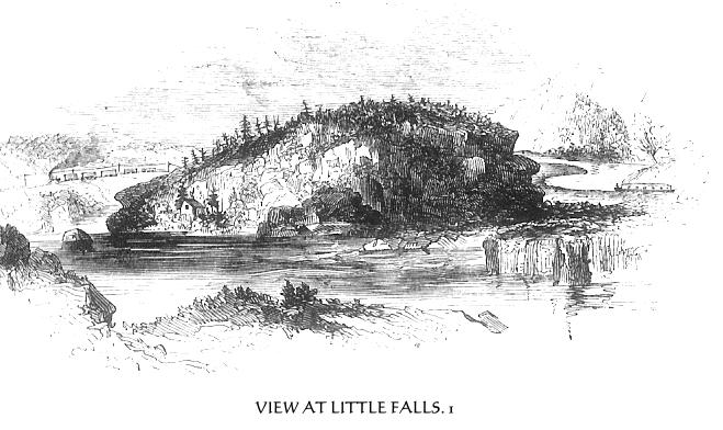
1 This view was taken from the rail-road near the village,
looking down the river. On the right is seen 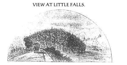 the
Erie Canal, and on the left, and more in the foreground, the Mohawk, at
the foot of the falls, with the rail-road and the magnetic highway. The
rugged bluff in the center is Moss Rock, at the lower extremity of which
is the gulf, seen in the annexed engraving. This view is from the tow-path,
below Moss Rock. On the left is the canal, and on the right are the gulf
and a portion of the village in the distance. Moss Rock is an island, formed
by the canal and the river. The summit of this amorphous pile has been suggested
as an appropriate site for the proposed monument to the memory of Dewitt
Clinton. It seems to me that the spot is singularly appropriate for that
purpose. The Erie Canal, with its busy commerce, is his perpetual memorial;
and here is the point where the most wonderful triumphs were achieved in
the construction of that stupendous work. Here, too, pass all travelers
to and from Niagara and the great West from the eastward, and the monument
would he seen, if erected there, by more persons than at any other locality
that may be named, out of the city of New York.
the
Erie Canal, and on the left, and more in the foreground, the Mohawk, at
the foot of the falls, with the rail-road and the magnetic highway. The
rugged bluff in the center is Moss Rock, at the lower extremity of which
is the gulf, seen in the annexed engraving. This view is from the tow-path,
below Moss Rock. On the left is the canal, and on the right are the gulf
and a portion of the village in the distance. Moss Rock is an island, formed
by the canal and the river. The summit of this amorphous pile has been suggested
as an appropriate site for the proposed monument to the memory of Dewitt
Clinton. It seems to me that the spot is singularly appropriate for that
purpose. The Erie Canal, with its busy commerce, is his perpetual memorial;
and here is the point where the most wonderful triumphs were achieved in
the construction of that stupendous work. Here, too, pass all travelers
to and from Niagara and the great West from the eastward, and the monument
would he seen, if erected there, by more persons than at any other locality
that may be named, out of the city of New York.
260
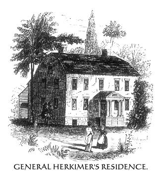 of
the traveler upon the rail-road, half a mile distant. It is a substantial
brick edifice. was erected in 1764, and was a splendid mansion for the time
and place. It is now owned by Daniel Conner, a farmer, who was modernizing
it when I was there, by building a long, fashionable piazza in front, in
place of the small old porch, or stoop, seen in the picture. He was also
improving some of the rooms within. The one in which General Herkimer died
(on the right of the front entrance), and also the one on the opposite side
of the passage, are left precisely as they were when the general occupied
the house; and Mr. Conner has the good taste and patriotism to preserve
them so. These rooms are handsomely wainscoted with white pine, wrought
into neat moldings and panels, and the casements of the deep windows are
of the same material and in the same style. Mr. Conner has carefully preserved
the great lock of the front door of the castle-for castle it really was,
in strength and appointments against Indian assaults. It is sixteen inches
long and ten wide. Close by the house is a subterranean room, built of heavy
masonry and arched, which the general used as a magazine for stores belonging
to the Tryon county militia. It is still used as a store-room, but with
more pacific intentions.
of
the traveler upon the rail-road, half a mile distant. It is a substantial
brick edifice. was erected in 1764, and was a splendid mansion for the time
and place. It is now owned by Daniel Conner, a farmer, who was modernizing
it when I was there, by building a long, fashionable piazza in front, in
place of the small old porch, or stoop, seen in the picture. He was also
improving some of the rooms within. The one in which General Herkimer died
(on the right of the front entrance), and also the one on the opposite side
of the passage, are left precisely as they were when the general occupied
the house; and Mr. Conner has the good taste and patriotism to preserve
them so. These rooms are handsomely wainscoted with white pine, wrought
into neat moldings and panels, and the casements of the deep windows are
of the same material and in the same style. Mr. Conner has carefully preserved
the great lock of the front door of the castle-for castle it really was,
in strength and appointments against Indian assaults. It is sixteen inches
long and ten wide. Close by the house is a subterranean room, built of heavy
masonry and arched, which the general used as a magazine for stores belonging
to the Tryon county militia. It is still used as a store-room, but with
more pacific intentions.
The family burial-ground is upon a knoll a few rods southeast of the mansion,
and there rest the remains 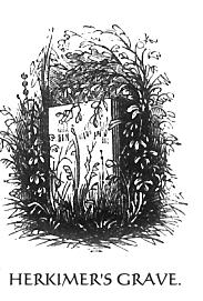 of
the gallant soldier, as secluded and forgotten as if they were of "common
mold." Seventy years ago the Continental Congress, grateful for his
services, resolved to erect a monument to his memory, of the value of five
hundred dollars; but the stone that may yet be reared is still in the quarry,
and the patriot inscription to declare its intent and the soldier's worth
is not yet conceived. Until 1847, no stone identified his grave. Then a
plain marble slab was set up, with the name of the hero upon it; and when
I visited it (1848), it was overgrown with weeds and brambles. It was erected
by his grand-nephew, W. Herkimer. The consecrated spot is in the possession
of strangers, and, but for this timely effort to preserve the identity of
the grave, the visitor might soon have queried, with the poet in search
of General Wooster's resting-place
of
the gallant soldier, as secluded and forgotten as if they were of "common
mold." Seventy years ago the Continental Congress, grateful for his
services, resolved to erect a monument to his memory, of the value of five
hundred dollars; but the stone that may yet be reared is still in the quarry,
and the patriot inscription to declare its intent and the soldier's worth
is not yet conceived. Until 1847, no stone identified his grave. Then a
plain marble slab was set up, with the name of the hero upon it; and when
I visited it (1848), it was overgrown with weeds and brambles. It was erected
by his grand-nephew, W. Herkimer. The consecrated spot is in the possession
of strangers, and, but for this timely effort to preserve the identity of
the grave, the visitor might soon have queried, with the poet in search
of General Wooster's resting-place
"O say, can none tell where the chieftain was laid?
Where our hero in glory is sleeping?
Alas! shall we never more seek out his grave,
While fame o'er his memory is weeping?"
Although General Herkimer was severely wounded at the battle of Oriskany, his death was the result of unskillful treatment, and, if tradition speaks truth, of criminal indulgence of appetite on the part of his surgeon. He was conveyed from the field on a litter to his residence. The weather was sultry, and the wound, which was a few inches below the (August 16,1777.) knee, became gangrenous. Nine days after the battle, a young French surgeon, who accompanied Arnold in his march up the valley, recommended amputation. Dr. Petrie, the general's medical adviser, was opposed to amputation, but it was done. The performance of the surgeon was so unskillful that the flow of blood was with great difficulty stanched. Indeed, the bleeding was not entirely checked, and it was thought advisable for the surgeon and his assistant to remain with the general, as his situation was very critical. Colonel Willett called to see him soon after the operation, and found him sitting up in his
261
bed, as cheerful as usual, and smoking his pipe. The blood continued to flow, and what little skill the surgeon possessed was rendered useless by indulgence in wine. No other physician was at hand, and toward evening, the blood still flowing, the general became convinced that his end was near. He called for the Bible, and read composedly, in the presence of his family and others, the thirty-eighth psalm, applying the deep, penitential confessions of the poem to his own case. He closed the book, sank back upon his pillow, and expired. Stone justly observes, "If Socrates died like a philosopher, and Rousseau like an unbelieving sentimentalist, General Herkimer died like a CHRISTIAN HERO.(1)'"
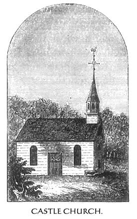 The
Castle Church, as it is called-the middle one of the three constructed under
the auspices of Sir William Johnson -- is still standing (1848.), two and
a half miles below the Herkimer mansion. It is a wooden building, and was
originally so painted as to resemble stone. Its present steeple is not ancient,
but its form is not unlike that of the original. Here the pious Kirkland
often preached the Gospel to the heathen, and here Brant and his companions
received lessons of heavenly wisdom. The church stood upon land that belonged
to the sachem, and the house of Brant, where Christian missionaries were
often entertained before he took up the war-hatchet, stood about seventy-five
rods northward of the church. Bricks and stones of the foundation were still
to be seen in an apple orchard north of the road, and the locality was well
defined, when I visited it, by rank weeks, nowhere else in the field so
luxuriant. I returned to Little Falls in time to dine and to take the western
train at one o'clock for Fort Plain, seventeen miles down the Mohawk. Fort
Plain (near the junction of Osquaga Creek and the Mohawk), one of the numerous
comely children brought forth and fostered by the prolific
The
Castle Church, as it is called-the middle one of the three constructed under
the auspices of Sir William Johnson -- is still standing (1848.), two and
a half miles below the Herkimer mansion. It is a wooden building, and was
originally so painted as to resemble stone. Its present steeple is not ancient,
but its form is not unlike that of the original. Here the pious Kirkland
often preached the Gospel to the heathen, and here Brant and his companions
received lessons of heavenly wisdom. The church stood upon land that belonged
to the sachem, and the house of Brant, where Christian missionaries were
often entertained before he took up the war-hatchet, stood about seventy-five
rods northward of the church. Bricks and stones of the foundation were still
to be seen in an apple orchard north of the road, and the locality was well
defined, when I visited it, by rank weeks, nowhere else in the field so
luxuriant. I returned to Little Falls in time to dine and to take the western
train at one o'clock for Fort Plain, seventeen miles down the Mohawk. Fort
Plain (near the junction of Osquaga Creek and the Mohawk), one of the numerous
comely children brought forth and fostered by the prolific 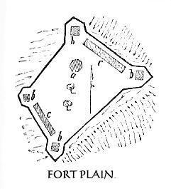 commerce
of the Erie Canal, is near the site of the fortification of that name, erected
in the Revolution. This fort (2) was eligibly situated upon a high plain
in the rear of the village, and commanded an extensive sweep of the valley
on the right and left. A sort of defense was thrown up there by the people
in the early part of the war, but the fort proper was erected by the government
after the alarming demonstrations of the Indians in the Mohawk and Schoharie
Valleys in 1778. For a while it was an important fortress, affording protection
to the people in the neighborhood, and forming a key to the communication
with the Schoharie, Cherry Valley, and Unadilla. settlements. Its form was
an irregular quadrangle, with earth and log bastions, embrasures at each
corner, and barracks and a strong block. house within. The plain on which
it stood is of peninsular form,
commerce
of the Erie Canal, is near the site of the fortification of that name, erected
in the Revolution. This fort (2) was eligibly situated upon a high plain
in the rear of the village, and commanded an extensive sweep of the valley
on the right and left. A sort of defense was thrown up there by the people
in the early part of the war, but the fort proper was erected by the government
after the alarming demonstrations of the Indians in the Mohawk and Schoharie
Valleys in 1778. For a while it was an important fortress, affording protection
to the people in the neighborhood, and forming a key to the communication
with the Schoharie, Cherry Valley, and Unadilla. settlements. Its form was
an irregular quadrangle, with earth and log bastions, embrasures at each
corner, and barracks and a strong block. house within. The plain on which
it stood is of peninsular form,
1 I was unsuccessful in my search for information respecting
the career of General Herkimer in youth and early manhood. He left no children.
Those of the family name are descendants of his only brother, George Herkimer.
His family was among the early settlers of the German Flats, and, though
opulent according to the standard of his times, he seems to have been quite
uneducated An old man whom I saw near the Flats remembered him as a large,
square-built Dutchman," and supposed him to have been about 65 years
old when he died. Should this meet the eye of any of his descendants, they
will confer a favor upon the author by communicating to him any information
they may possess concerning the general and his immediate family.
2 An aged resident of Fort Plain, Mr. David Lipe, whose house is near the
canal, below the old fortification, went over the ground with me, and I
made a survey of the outlines of the fort according to his directions. He
aided in pulling down the block-house when it was demolished after the war,
and his memory seemed to be very accurate. I am indebted to him for much
of the information here recorded concerning Fort Plain.
EXPLANATION OF THE PLAN.-The black line represents the parapet; a, the large
block-house; b b b b, small block-houses at each bastion; c
r, barracks. There were two large apple-trees within the fort, and
on the northern side of the hill is the living spring that supplied the
garrison with water.
262
and across the neck, or isthmus, a breast-work was thrown up. The fort extended along the brow of the hill northwest of the village, and the blockhouse was a few rods from the northern declivity. This blockhouse was erected in 1780, after the fort and barracks were found to be but a feeble defense, under the supervision of a French engineer employed by Colonel Gansevoort. The latter, by order of General Clinton, then in command of the Northern Department, had repaired thither with his regiment, to take charge of a large quantity of stores destined for Fort Schuyler. Ramparts of logs and earth were thrown up, and a strong block-house was erected, a view of which is here given. It was octagonal in form, three stories in height, and composed of hewn timbers about fifteen inches square. There were numerous port-holes for musketry, and in the lower story three or four cannons were placed. The first story was thirty feet in diameter, the second forty, and the third fifty. Each of the upper stories projected about five feet, and in the floor of each projection there were also port-holes, through which to fire perpendicularly upon an enemy below. The powder magazine of the fort was placed directly under the block-house for protection.
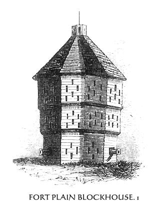 Some
time after the completion of the work, doubts were expressed of its being
cannon-ball proof. A trial was made with a six pounder placed at a proper
distance. Its ball passed entirely through the block-house, crossed a broad
ravine, and lodged in the hill on which the old parsonage stands, an eighth
of a mile distant. This proved the inefficiency of the building, and its
strength was increased by lining it with heavy planks. In order to form
a protection for the magazine against hot shot, the little garrison that
was stationed there in 1782 commenced throwing up a bank of earth around
the block-house. Rumors of peace, and the quiet that then prevailed in that
valley, caused the work to cease, and, happily, its resumption was never
demanded. The mounds which were raised on the south side of the block-house
were yet quite prominent when I visited the locality.(August 1848.)
Some
time after the completion of the work, doubts were expressed of its being
cannon-ball proof. A trial was made with a six pounder placed at a proper
distance. Its ball passed entirely through the block-house, crossed a broad
ravine, and lodged in the hill on which the old parsonage stands, an eighth
of a mile distant. This proved the inefficiency of the building, and its
strength was increased by lining it with heavy planks. In order to form
a protection for the magazine against hot shot, the little garrison that
was stationed there in 1782 commenced throwing up a bank of earth around
the block-house. Rumors of peace, and the quiet that then prevailed in that
valley, caused the work to cease, and, happily, its resumption was never
demanded. The mounds which were raised on the south side of the block-house
were yet quite prominent when I visited the locality.(August 1848.)
This place was included in the Canajoharie settlement, and in 1780 felt severely the vengeance of the Tories and Indians, inflicted in return for terrible desolations wrought by an army under Sullivan, the previous year, in the Indian country west of the white settlements. The whole region on the south of the Mohawk, for several miles in this vicinity, was laid waste. The approach of the dreaded Thayendanegea along the Canajoharie Creek, with about five hundred Indians and Tories, to attack the settlement at Fort Plain, was announced to the people, (August 2, 1780.) then engaged in their harvest fields, by a woman who fired a cannon at the fort. The larger portion of militia had gone with Gansevoort to guard provisions on their way to Fort Schuyler, and those who remained, with the boys and old men, unable to defend their lives or property, fled into the fort for protection. In their approach the enemy burned every dwelling and barn, destroyed the crops, and carried off every thing of value. Regardless of the strength of the fort, they marched boldly up within cannon-shot of the intrenchments, burned the church, the parsonage, and many other buildings,
1 There is considerable confusion in the accounts concerning Fort Plain, for which there is no necessity. There was a stockade about two miles southwest of Fort Plain, called Fort Clyde, in honor of Colonel Clyde, an officer in the Tryon county militia; and another about the same distance northwest, called Fort Plank, or Blank, from the circumstance that it stood upon land owned by Frederic Blank. The latter and Fort Plain have been confounded. Mr. Stone erroneously considered them as one, and says, in his Life of Brant (ii., 95), "The principal work of defense, then called Fort Plank, and subsequently Fort Plain, was situated upon an elevated plain overlooking the valley, near the site of the village still retaining the name of the fortress." Other writers have regarded the block-house as the fort, when, in fact, it was only a part of the fortifications. The drawing here given is from one published in Stone's Life of Brant, with a description from the Fort Plain Journal of December 26th, 1637. Mr. Lipe considered it a correct view, except the lower story, which, it was his impression, was square instead of octagonal, and had four port-holes for heavy ordnance.
263
and carried off several women and children prisoners. The house of Johannes
Lipe, the father of 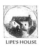 David,
my informant, which is still standing, was saved from plunder and fire by
the courage and presence of mind of his wife. She had been busy all the
evening carrying her most valuable articles from her house to a place of
concealment in a hollow at the rear, and had made several deposites there,
the last time she returned she met two prowling Indians at the gate. She
was familiar with their language, and, without any apparent alarm, inquired
of them if they knew anything of her two brothers, who were among the Tories
that fled to Canada. Fortunately, the savages had seen them at Oswegatchie,
and, supposing her to be a Tory likewise, they walked off, and the house
was spared.
David,
my informant, which is still standing, was saved from plunder and fire by
the courage and presence of mind of his wife. She had been busy all the
evening carrying her most valuable articles from her house to a place of
concealment in a hollow at the rear, and had made several deposites there,
the last time she returned she met two prowling Indians at the gate. She
was familiar with their language, and, without any apparent alarm, inquired
of them if they knew anything of her two brothers, who were among the Tories
that fled to Canada. Fortunately, the savages had seen them at Oswegatchie,
and, supposing her to be a Tory likewise, they walked off, and the house
was spared.
The church spire had a bright brass ball upon it, which the Indians believed
was gold. While the 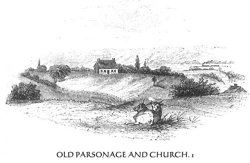 edifice
was burning, they waited anxiously for the steeple to fall, that they might
secure the prize. When it fell, the savages rushed forward, scattered the
burning timbers, and several of them in succession seized the glittering
ball. It was speedily dropped, as each paid the penalty of blistered fingers,
and dissevered that" all is not gold that glistens."
edifice
was burning, they waited anxiously for the steeple to fall, that they might
secure the prize. When it fell, the savages rushed forward, scattered the
burning timbers, and several of them in succession seized the glittering
ball. It was speedily dropped, as each paid the penalty of blistered fingers,
and dissevered that" all is not gold that glistens."
With the destruction of Fort Plain the devastation was, for the time, stayed. In a day the fairest portion of the valley had been made desolate. Fifty-three dwellings and as many barns were burned, sixteen of the inhabitants were slain, and between fifty and sixty persons, chiefly women and children, were made captives. More than three hundred cattle and horses were driven away, the implements of husbandry were destroyed, and the ripe grain-fields, just ready for the sickle, were laid in ashes.(2) The smoke was seen as far as Johnstown, and the people immediately left the fields and joined the Albany and Schenectady militia, then marching up the valley, under Colonel Wemple. The colonel seemed to be one of those men who deem prudence the better part of valor, and was opposed to forced marches, particularly when in pursuit of such fierce enemies as were just then attracting his attention. He managed to reach Fort Plain in time to see the smouldering embers of the conflagration, and to rest securely within its ramparts that night. The work of destruction was over, and the Indians and Tories were away upon another war-path.
At Fort Plain I was joined by my traveling companions, whom I had left at Syracuse, and made it my headquarters for three days, while visiting places of interest in the vicinity. It being a central point in the hostile movements in Tryon county, from the time of the flight of St. Leger from before Fort Stanwix until the close of the war, we will plant our telescope of observation here for a time, and view the most important occurrences within this particular sweep of its speculum. The battle of Minisink, and the more terrible tragedy in the Valley of Wyoming, radii in the hostile operations of the Indians and Tories from our point of view, will be noticed in other chapters. It is difficult to untie the complicated knot of events here, and make all parts perspicuous, without departing somewhat from the plan of the work, and taking up the events in chronological order. Every thing being subordinate to the history, I shall, therefore, make such departure for the present, and reserve my notes of travel until the story of the past is told.
1 This view is from the high plain
on the right of the block-house, looking north. The building upon the hill
across the ravine is the old parsonage, which was immediately built upon
the ruins of the one that was burned. On the left I have placed a church
in its proper relative position to the parsonage, as indicated by Mr. Lipe.
It was about half a mile northwest of the fort. On the right are seen the
Mohawk River and Plain, a train of cars in the distance, and the hills that
bound the view on the north side of the Mohawk Valley, in the direction
of Stone Arabia and Klock's Field, where two battles were fought in 1780.
These will be hereafter noticed.
2 Letter of Colonel Clyde. to Governor Clinton.