CHAPTER XXIII, Part TWO.
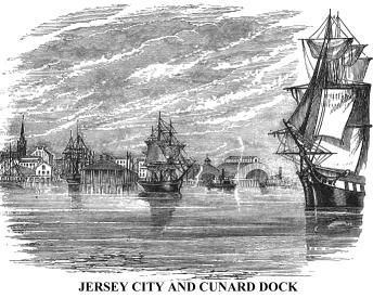
Opposite the lower part of the city of New York, and separated from Hoboken by a bay and marsh, is Jersey City, on a point at the mouth of the Hudson, known in early times as Paulus's or Pauw's Hook, it having been originally obtained from the Indians by Michael Pauw. This was an important strategic point in the revolution. Here the British established a military post after taking possession of the city of New York in 1776, and held it until August, 1779, when the active Major Henry Lee, mentioned in André's satire of "The Cow Chase," with his legion, surprised the garrison, killed a number, and captured the fort, just before the dawn. Now a flourishing city--a suburb of New York--covers that point. Immense numbers of travelers pass through it daily, it being the terminus of several important railways that connect with New York by powerful steam ferry-boats. Here, too, are the wharves of the Cunard line of ocean steamers. Before it is the broad and animated bay of New York, forming its harbour, and, stretching away to the south-west, nine miles or more, is Newark Bay, that receives the Passaic River.
Here we leave the Hudson proper, and after visiting some prominent places in the vicinity of the metropolis, will accompany the reader to the sea.
 Adjacent
to Manhattan Island, and separated from it by the narrow East River, is Long
Island, which stretches along the coast from West to East, about one hundred
and forty miles. It is rich in traditional, legendary, and historical reminiscences.
Near its western extremity, and opposite the city of New York, is the large
and beautiful city of Brooklyn,* whose intimate social and business relations
with the metropolis, and connection by numerous ferries, render it a sort
of suburban town. Its growth has been wonderful. Less than sixty years ago,
it contained only a ferry-house, a few scattered dwellings, and a church.
Now it comprises an area of 16,000 acres, with an exterior line of twenty-two
miles. Like New York, it has absorbed several villages. It was incorporated
a village in 1816, and a city in 1834. Its central portion is upon a range
of irregular hills, fortified during the revolution.
Adjacent
to Manhattan Island, and separated from it by the narrow East River, is Long
Island, which stretches along the coast from West to East, about one hundred
and forty miles. It is rich in traditional, legendary, and historical reminiscences.
Near its western extremity, and opposite the city of New York, is the large
and beautiful city of Brooklyn,* whose intimate social and business relations
with the metropolis, and connection by numerous ferries, render it a sort
of suburban town. Its growth has been wonderful. Less than sixty years ago,
it contained only a ferry-house, a few scattered dwellings, and a church.
Now it comprises an area of 16,000 acres, with an exterior line of twenty-two
miles. Like New York, it has absorbed several villages. It was incorporated
a village in 1816, and a city in 1834. Its central portion is upon a range
of irregular hills, fortified during the revolution.
*From the Dutch Breuck-landt--broken land.
The bluff on which Fort Stirling stood--now known as "The
Heights"--is covered with fine edifices, 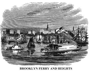 and
affords extensive views of New York and its harbour. Williamsburgh, which
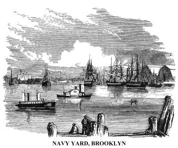
had become quite a large city, was annexed to Brooklyn in 1854. Between the
two cities is Wallabout Bay, the scene of great suffering among the American
prisoners, in British prison-ships, during the revolution. Eleven thousand
men perished there, and their remains were buried in shallow graves on the
shore. Near its banks was born Sarah Rapelje, the first child of European
parents that drew its earliest breath within the limits of the State of New
York.* Upon that aceldama of the old war for independence in the vicinity
of the Hudson, is now a dockyard of the United States Government, which covers
about forty-five acres of land. Within the enclosure is a depository of curious
things, brought home by officers and seamen of the navy, and is called the
Naval Lyceum. It contains a fine geological cabinet, and a library of several
thousand volumes. Upon a gentle hill back of the Navy Yard is a United States
Marine Hospital, seen in our sketch.
and
affords extensive views of New York and its harbour. Williamsburgh, which
had become quite a large city, was annexed to Brooklyn in 1854. Between the
two cities is Wallabout Bay, the scene of great suffering among the American
prisoners, in British prison-ships, during the revolution. Eleven thousand
men perished there, and their remains were buried in shallow graves on the
shore. Near its banks was born Sarah Rapelje, the first child of European
parents that drew its earliest breath within the limits of the State of New
York.* Upon that aceldama of the old war for independence in the vicinity
of the Hudson, is now a dockyard of the United States Government, which covers
about forty-five acres of land. Within the enclosure is a depository of curious
things, brought home by officers and seamen of the navy, and is called the
Naval Lyceum. It contains a fine geological cabinet, and a library of several
thousand volumes. Upon a gentle hill back of the Navy Yard is a United States
Marine Hospital, seen in our sketch.
* In April, 1623, thirty families chiefly Walloons (French Protestants who had taken refuge in Holland), arrived at Manhattan, in charge of the first Governor of New Netherland. Eight of these families went up the Hudson, and settled at Albany; the remainder chose their place of abode across the channel of the East River, upon lands now covered by a portion of the city of Brooklyn and the United States Navy Yard.
 The
southern portion of Brooklyn lies upon low ground, with an extensive water
front. There, immense commercial works have been constructed, known as the
Atlantic Docks, covering forty acres, and affording within the "slips"
water of sufficient depth for vessels of largest size. There is an outside
pier, three thousand feet in length, and on the wharves are extensive warehouses
of granite. These wharves afford perfect security from depredators to vessels
loading and unloading.
The
southern portion of Brooklyn lies upon low ground, with an extensive water
front. There, immense commercial works have been constructed, known as the
Atlantic Docks, covering forty acres, and affording within the "slips"
water of sufficient depth for vessels of largest size. There is an outside
pier, three thousand feet in length, and on the wharves are extensive warehouses
of granite. These wharves afford perfect security from depredators to vessels
loading and unloading.
A little below Brooklyn, and occupying a portion of the ground
whereon the conflict between the British and American armies, known as the
battle of Long Island, was fought, at the close of the summer of 1776, is
Greenwood Cemetery, one of the most noted burial-places in the country. A
greater portion of it is within the limits of the city of Brooklyn. 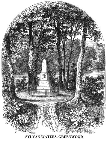 It
comprises four hundred acres of finely diversified land. The present population
of that "city of the dead" is probably not less than 70,000. One
of the most delightful places within its borders is Sylvan Water, near the
shores of which may be seen a monument, over the grave of an Indian princess,
of the tribe of Min-ne-ha-ha, the bride of Longfellow's Hi-a-wat-ha, who died
in New York a few years ago. Also the grave of M'Donald Clarke, known in New
York, twenty years ago, as the "Mad Poet." His monument is seen
upon a little hillock in our sketch of Sylvan Water. Clarke was an eccentric
child of genius. He became, in his latter years, an unhappy wanderer, with
reason half dethroned, a companion of want, and the victim of the world's
neglect. His proud spirit disdained to ask food, and he famished. Society,
of whom his necessities asked bread, "gave him a stone"--a monument
of white marble, with his profile in bas-relief. He died in March, 1842. "He
was a poet," says his biographer, "of the order of Nat Lee; one
of those wits, in whose heads, according to Dryden, genius is divided from
madness by a thin partition.*
It
comprises four hundred acres of finely diversified land. The present population
of that "city of the dead" is probably not less than 70,000. One
of the most delightful places within its borders is Sylvan Water, near the
shores of which may be seen a monument, over the grave of an Indian princess,
of the tribe of Min-ne-ha-ha, the bride of Longfellow's Hi-a-wat-ha, who died
in New York a few years ago. Also the grave of M'Donald Clarke, known in New
York, twenty years ago, as the "Mad Poet." His monument is seen
upon a little hillock in our sketch of Sylvan Water. Clarke was an eccentric
child of genius. He became, in his latter years, an unhappy wanderer, with
reason half dethroned, a companion of want, and the victim of the world's
neglect. His proud spirit disdained to ask food, and he famished. Society,
of whom his necessities asked bread, "gave him a stone"--a monument
of white marble, with his profile in bas-relief. He died in March, 1842. "He
was a poet," says his biographer, "of the order of Nat Lee; one
of those wits, in whose heads, according to Dryden, genius is divided from
madness by a thin partition.*
From two or three prominent points in Greenwood Cemetery fine views of New York city and bay may be obtained, but a better comprehension of the scenery of the harbour, and adjacent shores, may be had in a voyage down the Bay to Staten Island.* *
* Duyckinck's "Cyclopaedia of American Literature."
** This island was purchased from the Indians in 1630, by the proprietor of the land on which jersey city now stands, and all of that vicinity. It reverted to the Dutch West Indian company, when it was called Status Eylandt, or the State's Island. A considerable number of French Protestants (Huguenots), who fled to American under the revocation of the Edict of Names, settled on Staten Island. The British troops took possession of the island in 1776, and held it until the autumn of 1783.
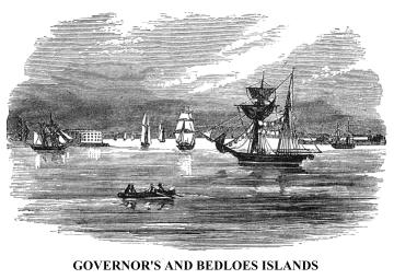 This
may be accomplished many times a day, on steam ferry-boats, from the foot
of Whitehall Street, near "The Battery." As we go out from the "slip,"
we soon obtain a general view of the harbour. On the left is Governor's Island,
with Castle Williams upon its western extremity, and Fort Columbus lying upon
its crown, shaded with old Lombardy poplars. On the right is Bedloe's Island,*
mostly occupied by Fort Wood, a heavy fortification, erected in 1841. Near
it is Ellis's Island, with a small military work, called Fort Gibson. This
was formerly named Gibbet Island, it being then, as now, the place for the
execution of pirates. These islands belong to the United States. The forts
upon them were used as prisons for captured soldiers of the armies in rebellion
during the Civil War.
This
may be accomplished many times a day, on steam ferry-boats, from the foot
of Whitehall Street, near "The Battery." As we go out from the "slip,"
we soon obtain a general view of the harbour. On the left is Governor's Island,
with Castle Williams upon its western extremity, and Fort Columbus lying upon
its crown, shaded with old Lombardy poplars. On the right is Bedloe's Island,*
mostly occupied by Fort Wood, a heavy fortification, erected in 1841. Near
it is Ellis's Island, with a small military work, called Fort Gibson. This
was formerly named Gibbet Island, it being then, as now, the place for the
execution of pirates. These islands belong to the United States. The forts
upon them were used as prisons for captured soldiers of the armies in rebellion
during the Civil War.
* So named from Isaac Bedloe the patentee under Governor Nicholson.
Before the voyager down the bay lies Staten Island, which,
with the western end of Long Island,  presents
a great barrier to the ocean winds and waves, and affords a shelter to vessels
in the harbour of New York from the tempest outside. It is nearly oval-shaped,
fourteen miles in length, and eight in breadth. It was heavily wooded, and
sparsely settled, when the British army occupied it, in the summer of 1776.
Now, the hand of cultivation is everywhere visible. Its shores bordering on
New York Bay are dotted with lively villages, and all over the broad range
of hills that extend from the Narrows, across the island, are superb country-seats,
and neat farmhouses. It is a favourite place of summer residence for the wealthy
and business men of New York--easy of access, and salubrious. These country-seats
usually overlook the bay. The tourist will find an excursion over this island
a delightful one.
presents
a great barrier to the ocean winds and waves, and affords a shelter to vessels
in the harbour of New York from the tempest outside. It is nearly oval-shaped,
fourteen miles in length, and eight in breadth. It was heavily wooded, and
sparsely settled, when the British army occupied it, in the summer of 1776.
Now, the hand of cultivation is everywhere visible. Its shores bordering on
New York Bay are dotted with lively villages, and all over the broad range
of hills that extend from the Narrows, across the island, are superb country-seats,
and neat farmhouses. It is a favourite place of summer residence for the wealthy
and business men of New York--easy of access, and salubrious. These country-seats
usually overlook the bay. The tourist will find an excursion over this island
a delightful one.
 On
the northern extremity of Staten Island, the State of New York established
a quarantine as early as 1799, and maintained it until the beginning of September,
1858, when the inhabitants of the village that had grown up there, and of
the adjacent country, who had long petitioned for its removal as a dangerous
nuisance, destroyed all the buildings by fire. There had been more than five
hundred cases of yellow fever there two years before, and the distress and
alarm created by that contagion made the people determine to rid themselves
of the cause. Since the destruction of the establishment, a hospital-ship,
to serve quarantine purposes, has been anchored in the lower bay, preparatory
to some permanent arrangement.
On
the northern extremity of Staten Island, the State of New York established
a quarantine as early as 1799, and maintained it until the beginning of September,
1858, when the inhabitants of the village that had grown up there, and of
the adjacent country, who had long petitioned for its removal as a dangerous
nuisance, destroyed all the buildings by fire. There had been more than five
hundred cases of yellow fever there two years before, and the distress and
alarm created by that contagion made the people determine to rid themselves
of the cause. Since the destruction of the establishment, a hospital-ship,
to serve quarantine purposes, has been anchored in the lower bay, preparatory
to some permanent arrangement.
From the Quarantine Dock may be obtained an excellent view
of the Narrows, the ship channel between Long and Staten Islands through which
vessels pass to and from the sea. Our little sketch gives a comprehensive
view of that broad gate to the harbour of New York. On the right is seen Staten
Island, with the new and substantial battery on the water's edge, just below
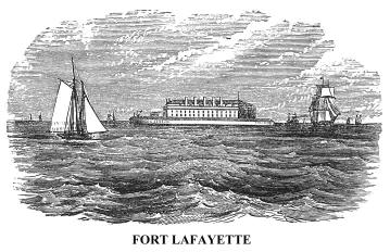
the unfinished Fort Wadsworth (formerly Fort Richmond). On the left is the
Long Island shore, with Fort Hamilton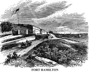 on its high bank, and Fort Lafayette, formerly Fort Diamond, in the stream
below. The latter fort is upon Hendrick's Reef, two hundred yards from the
Long Island shore. It was commenced in 1812, but had not been thoroughly completed
when the Civil War commenced, although 350,000 dollars had been spent upon
it. It was then capable of having mounted seventy-five heavy guns. It soon
became famous as a political state prison in which many citizens, charged
with disloyal, seditious, and treasonable acts toward the Government, were
confined. Among them was Mr. Faulkner, of Virginia, who was the United States
minister to the French Court during Mr. Buchanan's administration; the mayor
and chief of police of Baltimore; members of the Maryland legislature, and
the mayor of Washington city. The latter was released after a short confinement,
on taking the oath of allegiance.
on its high bank, and Fort Lafayette, formerly Fort Diamond, in the stream
below. The latter fort is upon Hendrick's Reef, two hundred yards from the
Long Island shore. It was commenced in 1812, but had not been thoroughly completed
when the Civil War commenced, although 350,000 dollars had been spent upon
it. It was then capable of having mounted seventy-five heavy guns. It soon
became famous as a political state prison in which many citizens, charged
with disloyal, seditious, and treasonable acts toward the Government, were
confined. Among them was Mr. Faulkner, of Virginia, who was the United States
minister to the French Court during Mr. Buchanan's administration; the mayor
and chief of police of Baltimore; members of the Maryland legislature, and
the mayor of Washington city. The latter was released after a short confinement,
on taking the oath of allegiance.
On the eastern border of the Narrows stands Fort Hamilton, a strong fortification completed in 1832, when a war with France seemed to be impending. It was enlarged and strengthened during the Civil War. At the beginning of the rebellion it mounted sixty heavy guns (a portion of them en barbette), forty-eight of which bore upon the ship channel. The fort is elevated, and commands the Lower Bay from the Narrows towards Sandy Hook. This work, with the fortifications on the opposite shore of Staten Island, and the water battery of Fort Lafayette in the channel, render the position, at the entrance to New York Bay, almost impregnable.
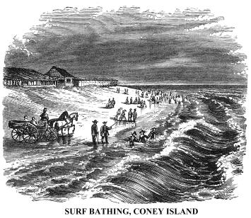 A
delightful voyage of fifteen minutes in a steamer, or half an hour in a sail-boat,
will take us to Coney Island, once a peninsula of Long Island at the lower
end of Gravesend Bay. It is now connected with the main, by a good road, a
causeway, and a bridge. The island is about five miles in length, and one
in width, and contains about sixty acres of arable land. The remainder is
made up of sand dunes, formed by the action of the winds. These resemble snow-drifts,
and are from five to thirty feet in height. It is a favourite summer resort
for bathers, its beach being unsurpassed. Near the Pavilion, at its western
end, the scene of our little sketch, the beach is very flat, and surf bathing
is perfectly safe. There crowds of bathers of both sexes, in their sometimes
grotesque dresses, may be seen every pleasant day in summer, especially at
evening, enjoying the water. Refreshments are served at the Pavilion near,
and a day may be spent there pleasantly and profitably. There are two or three
summer boarding-houses at the other end of the island, which may be reached
from Brooklyn in the space of forty-five minutes, by railways.
A
delightful voyage of fifteen minutes in a steamer, or half an hour in a sail-boat,
will take us to Coney Island, once a peninsula of Long Island at the lower
end of Gravesend Bay. It is now connected with the main, by a good road, a
causeway, and a bridge. The island is about five miles in length, and one
in width, and contains about sixty acres of arable land. The remainder is
made up of sand dunes, formed by the action of the winds. These resemble snow-drifts,
and are from five to thirty feet in height. It is a favourite summer resort
for bathers, its beach being unsurpassed. Near the Pavilion, at its western
end, the scene of our little sketch, the beach is very flat, and surf bathing
is perfectly safe. There crowds of bathers of both sexes, in their sometimes
grotesque dresses, may be seen every pleasant day in summer, especially at
evening, enjoying the water. Refreshments are served at the Pavilion near,
and a day may be spent there pleasantly and profitably. There are two or three
summer boarding-houses at the other end of the island, which may be reached
from Brooklyn in the space of forty-five minutes, by railways.
Between Coney Island and Sandy Hook, is an expanse of water,
several miles across, in which is 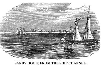 the
sinuous channel followed by large vessels in their entrance to and exit from
the harbour of New York in charge of the pilots. To the right, beyond Raritan
Bay, is seen the New Jersey shore; while southward, in the blue distance,
loom up the Navesink Highlands, on which stand the lighthouses first seen
by the voyager from Europe, when approaching the port of New York.
the
sinuous channel followed by large vessels in their entrance to and exit from
the harbour of New York in charge of the pilots. To the right, beyond Raritan
Bay, is seen the New Jersey shore; while southward, in the blue distance,
loom up the Navesink Highlands, on which stand the lighthouses first seen
by the voyager from Europe, when approaching the port of New York.
Sandy Hook is a long, low, narrow strip of sandy land, much of it covered with shrubs and dwarf trees. It is about five miles in length, from the Navesink Lights to its northern extremity, whereon are two lighthouses. It is the southern cape of Raritan Bay, and has twice been an island, within less than a century. An inlet was cut through by the sea during a gale in 1778, but closed again in the year 1800. Another inlet was cut in 1830, and for several years it was so deep and broad that steamboats passed through it. That is now closed.
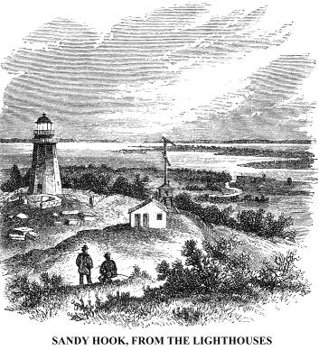 At
the northern extremity of Sandy Hook, the United States are now erecting strong
fortifications. These will materially strengthen the defences of the harbour
of New York, as this fort will command the ship channel. About a mile below
the pier, near the lighthouse, on the inner shore of the Hook, once stood
an elegant monument, erected to the memory of a son of the Earl of Morton,
and thirteen others, who were cast away near there, in a snow-storm, during
the revolution, and perished. All but one were officers of a British man-of-war,
wrecked there. They were discovered, and buried in one grave. The mother of
the young nobleman erected the monument, and it remained, respected even by
the roughest men of the coast, until 1808, when some vandals, from a French
vessel-of-war, landed there, and destroyed that beautiful memorial of a mother's
love.
At
the northern extremity of Sandy Hook, the United States are now erecting strong
fortifications. These will materially strengthen the defences of the harbour
of New York, as this fort will command the ship channel. About a mile below
the pier, near the lighthouse, on the inner shore of the Hook, once stood
an elegant monument, erected to the memory of a son of the Earl of Morton,
and thirteen others, who were cast away near there, in a snow-storm, during
the revolution, and perished. All but one were officers of a British man-of-war,
wrecked there. They were discovered, and buried in one grave. The mother of
the young nobleman erected the monument, and it remained, respected even by
the roughest men of the coast, until 1808, when some vandals, from a French
vessel-of-war, landed there, and destroyed that beautiful memorial of a mother's
love.
Here, reader, on the borders of the great sea, we will part company for a season. We have had a pleasant and memorable journey from the Wilderness, three hundred miles away to the northward, where the forest shadows eternally brood, and the wild beasts yet dispute for dominion with man. We have looked upon almost every prominent object of Nature and Art along the borders of the Hudson, and have communed profitably, I hope, with History and Tradition on the way. We have seen every phase of material progress, from Nature in her wildest forms, to Civilization in its highest development. Our journey is finished--our observations have ceased--and here, with the yielding sand beneath our feet, a cloudless sky bending over us, and the heaving ocean before us--
" The sea! the sea! the open sea!
The blue, the fresh, the ever free!"--
we will say Farewell!
The End
Copyright © 1998, -- 2004. Berry Enterprises. All rights reserved. All items on the site are copyrighted. While we welcome you to use the information provided on this web site by copying it, or downloading it; this information is copyrighted and not to be reproduced for distribution, sale, or profit.
![]()