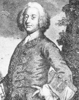
 <-Sir
William Johnson.
<-Sir
William Johnson.Three Rivers
Hudson~Mohawk~Schoharie
History From America's Most Famous Valleys
Trappers
of New York
or a BIOGRAPHY of NICHOLAS STONER & NATHANIEL FOSTER;
TOGETHER WITH ANECDOTES OF OTHER CELEBRATED HUNTERS,
AND SOME ACCOUNT OF SIR WILLIAM JOHNSON AND HIS STYLE OF LIVING
by Jeptha R. Simms
A
Reprint with New Supplementary Matter
Printed by Enterprise
and News
St. Johnsville, N.Y. 1935
Albany: J. Munsell, 82 State Street. 1850
CHAPTER
II.
REASONS FOR SIR WM. JOHNSON'S LOCATING
IN JOHNSTOWN
Scenery between the Mohawk and Sacondaga, rivers -The great Sacondaga Vlale-Vlaie Creek-Its source and Indian name-Origin of the marsh-Singular discovery of a lake-Stacking-ridge-sCranberries-Johnson's cottage on Summerhouse point-His carriage road-Nine mile tree -Sacondaga Patent-Summer-house how built and painted-Its Garden-Creek entering the Vlaie--Origin of their names-Summer-house point in freshets-Wild game-Visit to the point in 1849.
<-Sir
William Johnson.
Sir William Johnson was no doubt induced to locate in Johnstown, partly on account of the greater facilities it would afford him for hunting and fishing about the Sacondaga river, over a residence in the Mohawk valley, and partly to obtain more favorable grounds to accommodate the numerous Indians, who at times came to receive presents from the royal bounty. North of the Hall was a forest in which those visitors were occasionally encamped in great numbers.
The Sacondaga and Mohawk rivers are about twenty miles apart, from the Fish House westward, for some distance. The Mayfield mountain stretches across from the former river southeasterly to the latter, and there forms what is called The Nose, while on the north side of the Sacondaga, mountain ranges of hills towering one above the other, bound the view. The lands, on gaining the summit level, a few miles north of the Mohawk, are not mountainous between the rivers, but gently rolling from the Mayfield mountain, some twenty miles to the eastward, until they strike what is denominated the Maxon hill; the northern termination of which at the river the Indians called Scow-a-rock-a. The scenery, therefore, to the northward of Johnstown and Fonda's Bush, is very fine.
From the residence of Col. John I. Shew, situated on an eminence one and a half miles from Fonda's Bush, and on the plank road to Fish House, is afforded the lover of natural science, in a clear day, one of the richest landscapes in this part of the state. Here the eye, looking north, seems to scan rather more than one-half of an amphitheatre, an hundred miles in circuit, with rich and varied scenery. Within the view is overlooked the Sacondaga vlaie, a body of from ten to thirteen thousand acres of drowned lands. This immense marsh extends east and west about six miles. A strip at the west end, nearly two miles long, lies in Mayfield, and the eastern part extends into Northampton; but the greatest proportion is in Broadalbin, where it is the widest, being perhaps a mile or more in width.
A fine mill stream, called Vlaie creek, because it courses through the great marsh, rises in Lake Desolation, near the Maxon mountain in Greenfield, Saratoga county, and making a grand circuit of Broadalbin, passing in its route through the village of Fonda's Bush, it enters the Sacondaga at Fish House, not more than two or three miles from its source; although some twenty by its sinuous route. The stream is sometimes called the Little Sacondaga. The Indians called it Ken-ny-ett-o, says Isaac R. Rosa, of Fonda's Bush, who saw an intelligent Indian, many years ago, write the name with red chalk on the door of a grist mill (1). The significance of this pretty aboriginal name, after which the village and post-office should have been called, is now unknown.
The origin of this marsh is thus given by Lardner Vanuxem, in his volume of the Geology of New York: "The vlaie, or natural meadow and swamp which extends along the creek of that name, to near the Fish House, are the remains of a lake, and show the pre-existent state of that country; the drainage of which happened at successive periods, as is beautifully shown, and the extent of alluvial action also, near where the upper and lower roads unite, which lead from Cranberry post-office to the river, near the hill or mountain side. There four well defined alluvial banks exist, resembling great steps or benches ranging by the mountain side, which form a semiamphitheatre, changing by a curve from a northeast to a south-south-east direction. The upper bank of alluvian rises about a hundred feet above the river; the next below, about eighty feet; the third, from thirty to forty feet; and the lowest, from ten to twelve feet. The upper one is of sand, the second of bluish clay covered with sand, and the two lower ones of sand and gravel.
"The vlaie, or natural meadows, are numerous in many parts of the (geological) district; they are the prairies of the west upon a small scale. Their soil, being composed of minutely divided parts of fine earth, is favorable for grass, the rapid growth of which smothers the germinating tree. This is the primary cause why trees do not exist where grass is rank; the others are but subordinate ones. One and all in the district show the same origin, having been ponds or lakes receiving the wash of the country which they drained, the finer particles of which being diffused through their waters, have by subsidence formed their level bottom, and their highly productive soil for grass."
It is by no means an uncommon occurrence for a pond,or lake to become filled up by alluvial deposits, so as to form dry and tillable land; and at times upon the surface of a body of water, a soil is formed that is cultivated without its ever being known to the husbandman, that he is toiling over the bosom of a lake. In confirmation of this I would instance a singular occurrence of recent date. On the Michigan Central Railway it became necessary to carry an embankment some fifteen feet thick across a piece of low ground, containing nearly one hundred acres dry enough to plow. The workmen had progressed with the grading some distance, when it became too heavy for the soil to support it, and it sank down into seventy-nine feet -of water. It then became apparent that the low ground had been a small lake, upon the surface of which, in process of time, a soil had collected, composed of roots, peat, muck, &c., to the depth of from ten to fifteen feet thick; the surface of which had become dry. Had it not been deemed necessary to carry so heavy an embankment over this miniature prairie of now rich arable land, it would probably never have been know that it rested on the bosom of a lake.
On the northerly side of the vlaie and to the westward of the center, are two strips of hard land bearing timber. They are called stacking-ridges, from the fact that many tons of hay cut annually on the low grounds contiguous, are stacked upon them to be drawn off in the winter. Blue-joint grass used to grow, and perhaps does to this day on the dryest bogs. Formerly immense quantities of cranberries were gathered on the north side of the marsh east of the lower stacking-ridge, on what is called Cranberry point. A kind of shovel with fine teeth was sometimes used to scoop them up, and nearly a quart could thus be gathered at once. This mode of picking injured the vines however. Opposite Cranberry point the water in Vlaie creek is said to be very deep.
Summerhouse point is approached from the westerly end, upon a strip of arable land, which in very high water is covered, making an island of the point. The Sacondaga patent embraced all or very nearly all of the vlaie. The point which lies in Broadalbin, was embraced in the Sacondaga patent, which conveyed 28,000 acres of land, Dec. 2, 1742, to Lendert Ganesvoort, Cornelius Ten Brock, Douw Fonda, Anna J. Wendell and ten others. Of some of the original patentees or then owners, Sir William not only bought the point, but many of the lands in and contiguous to Fish House, in which village the Northampton and Sacondaga, patents unite.
The cottage erected on Summerhouse point stood precisely in its centre. It was a tasty one story building, fronting the south, upon which side was its front entrance. The roof sloped north and south. A piazza supported by square columns extended around the side and east end, with a promenade upon the top nearly as high as the eaves. It had a gable window at each end on the first floor, and two windows at each end on the second. A hall ran across the building in the centre, with a square room upon each side of it, handsomely finished, well furnished, and each room lighted by two front windows. It had a nice cellar kitchen, the entrance to which was on the west end which room was always occupied in the summer season by Nicholas and Flora, a pair of the Baronet's slaves, who were there to keep every thing in order, and minister to his comfort during his visits. The cottage was painted white, with the comers, doors, window casings and columns painted green, as was the English taste of the times-the whole contrasting beautifully with the wild scenery around.
A large garden was cultivated on the point, two cows kept there, and when the Baronet was there two horses also; as he usually rode there in a carriage. He planted fruit trees there, and two antiquated apple trees of a dozen or more are still standing. The stone of which the cellar and well were made, were brought from Fish House in a boat, and as stone were scarce on the sandy lands contiguous, early settlers with sacrilegious propensity have carried off and converted them to other uses. The plow has removed all traces of the well, which was on the verge of the knoll south of the house, and has nearly filled the cellar, a small cavity only remaining. A log house and well were built on the south side of the point toward the western end just after the revolution, but the dwelling is now gone, and most of the stone which were used in that cellar. The nearest house now to the point, is that known as the Brown place, where Samuel Brown, an old pensioner, lived and died.
I have said that the Kennyetto coursed through the vlaie. It enters a narrow strip of it southwest of the point, and runs along the latter upon its southerly side, where it is some two rods wide, and usually three or four feet deep. The Mayfield creek, a millstream about two-thirds as large as the Kennyetto, runs through that part of the marsh in Mayfield, and sweeping its north margin, unites with the latter stream at the extremity of the point. The Brown farm lies between the two strips of the marsh named, and near where they approximate. Besides those named, several other streams enter the marsh. On the north side at Cranberry point, a mile from Summerhouse point, Cranberry creek runs in, and nearly loses itself before reaching Vlaie creek, as the stream is called after it receives Mayfield creek. On the south side two mill streams run in, in Broadalbin, one nearly opposite Cranberry creek, called formerly Frenchman's creek, and the other a mile below called Han's creek; and yet so great is the natural process of absorption and evaporation constantly going on here, that the creek, where it issues from the vlaie and enters the Sacondaga at Fish House, discharges but little if any more water than passes Summerhouse point, in the Kennyetto; indeed, it is said by some of the observing citizens near its mouth, that less water issues from the marsh than did formerly.
Frenchman's creek is so called, because a Frenchman named Joseph DeGolier located at an early day upon its shores about five miles from its mouth. It has since been called McMartin's creek, after Duncan McMartin, Esq., who established himself and erected mills upon it many years ago. McMartin was a surveyor and laid out most of the roads in and around Broadalbin. He was a man of wealth and respectability, and was appointed a judge of the common pleas in 1818-was a master in chancery, &c., &c.; and as an evidence of his enterprise, erected a substantial brick edifice upon his farm, some few years before his death. This same stream has also been called Factory creek, from the fact that a woolen manufactory was established upon it near the residence of Mr. McMartin, as early as 1812 or 1814. It is still in operation. Han's creek got its name from the following circumstance: Some few years before his death, Sir William Johnson and John Conyne were fishing for trout in the mouth of this stream, when as Conyne was standing up, an unexpected lurch of the boat sent him out floundering in the water. He shipped a sea or two, as the sailor would say, before he was rescued by the helping hand of his companion from a watery grave. My informant heard the Baronet relate the circumstance at Johnson Hall to a large circle of friends soon after, with his usual gusto for such adventures. He not only had a hearty laugh over it then, but often afterwards when telling how Conyne plunged into the water to seek for trout. Hans being the Dutch of John, and the familiar name by which Sir William called his companion in relating the incident; hence the name for the stream.
There is now along the sides and lower end of Summerhouse point, a stunted growth of alder and swamp willow, but when occupied by Sir William Johnson, the bushes were all cut off, and the margin of the stream kept clean. He had a beautiful boat there, in which he used to go down to the Fish House, four miles distant, sometimes with company, for he entertained numerous distinguished guests, and at other times attended only by a few servants, or possibly by his faithful Pontioch, who rowed the boat while he sat in the stem and steered it. His greatest time for hunting and fishing was in the spring and fall. When the marsh was flooded, a boat would pass over it any where, the water rising at Summerhouse point, from six to eight feet above low water mark. At such times the prospect was grand from the promenade of his cottage, access to which was gained by an outside stairway, near the hall door. Thousands upon thousands of ducks and wild geese were then floating upon the waters, at which time his double-barreled gun was in almost constant requisition. Some twenty-five years ago, ducks used to breed about the vlaie. They are sometimes caught in nets there, and taken to market.
In company with Dr. William Chambers, Marcellus Weston, Esq., my patriotic old friends Jacob Shew, Col. John 1. Shew his son and little Haydn Shew, I visited Summerhouse point on the 29th day of August, 1849, and well was I compensated for the journey. It is a most delightful place, divested of all historic associations, but clothed with them, it is one of the most interesting spots imaginable. Recreating in fancy the white cottage with green facings, I could almost hear the notes of Billy's old fiddle, as his greatest skill was taxed to please the car of some fastidious city guest; and at some witticism of the happy host, I seemed to hear peal after peal of merry laughter, and now and then an Indian whoop, as in former days they rang out upon the gentle breeze. The fairy craft of some forest son seemed once more to be gliding along the grass-hidden stream with its blanket-dad navigator standing erect as of yore, and bound for Sacondaga. Imagination pictures Pontioch caressing his favorite steeds, and calling on Nicholas to aid a black driver in rubbing them dry; and as I passed the entrance to Flora's department, to look at the noble animals. I seemed to see upon one side of it scores of pigeons and wild ducks, with the saddle of a deer; and on the other a large heap of golden trout, to supply the cottage larder and feed its guests.
But I find I am growing visionary, and will dismiss this subject, with my grateful thanks to the gentlemen who conducted me to Summerhouse point, where I trust I may again light up "the council fires" of imagination-again be surrounded by intelligent friends-again see some little Haydn hooking perch or sun fish-again see the happy hay makers near the upper stocking-ridge and again seek for some relic of the point's first occupancy, if only to be rewarded by the limb of an old apple tree.
Copyright © 1998, -- 2003. Berry Enterprises. All rights reserved. All items on the site are copyrighted. While we welcome you to use the information provided on this web site by copying it, or downloading it; this information is copyrighted and not to be reproduced for distribution, sale, or profit.